You are here: Home > Network List > AZ - ANZA Regional Network Stations List
> Station KNW AZ.KNW > Earthquake Result Viewer
KNW AZ.KNW - Earthquake Result Viewer
| Earthquake location: |
Western Brazil |
| Earthquake latitude/longitude: |
-8.3/-71.7 |
| Earthquake time(UTC): |
2002/10/12 (285) 20:09:11 GMT |
| Earthquake Depth: |
534 km |
| Earthquake Magnitude: |
6.5 MB, 6.9 MW, 6.9 MW |
| Earthquake Catalog/Contributor: |
WHDF/NEIC |
|
| Network: |
AZ ANZA Regional Network |
| Station: |
KNW AZ.KNW |
| Lat/Lon: |
33.71 N/116.71 W |
| Elevation: |
1507 m |
|
| Distance: |
59.7 deg |
| Az: |
316.978 deg |
| Baz: |
125.896 deg |
| Ray Param: |
0.059923146 |
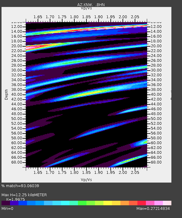
| Estimated Moho Depth: |
12.25 km |
| Estimated Crust Vp/Vs: |
1.97 |
| Assumed Crust Vp: |
6.264 km/s |
| Estimated Crust Vs: |
3.184 km/s |
| Estimated Crust Poisson's Ratio: |
0.33 |
|
| Radial Match: |
93.06039 % |
| Radial Bump: |
296 |
| Transverse Match: |
65.29827 % |
| Transverse Bump: |
400 |
| SOD ConfigId: |
4714 |
| Insert Time: |
2010-02-26 19:29:32.627 +0000 |
| GWidth: |
2.5 |
| Max Bumps: |
400 |
| Tol: |
0.001 |
|
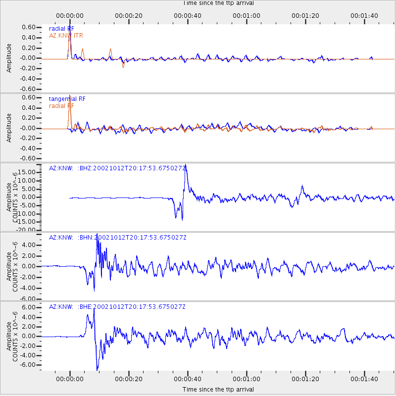
Signal To Noise
| Channel | StoN | STA | LTA |
| AZ:KNW: :BHN:20021012T20:17:53.675027Z | 0.8527857 | 6.499278E-7 | 7.6212325E-7 |
| AZ:KNW: :BHE:20021012T20:17:53.675027Z | 1.0616456 | 3.2418404E-7 | 3.0535992E-7 |
| AZ:KNW: :BHZ:20021012T20:17:53.675027Z | 2.7747185 | 3.3985458E-7 | 1.2248255E-7 |
| Arrivals |
| Ps | 2.0 SECOND |
| PpPs | 5.6 SECOND |
| PsPs/PpSs | 7.6 SECOND |


