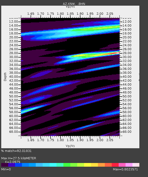
KNW AZ.KNW - Earthquake Result Viewer
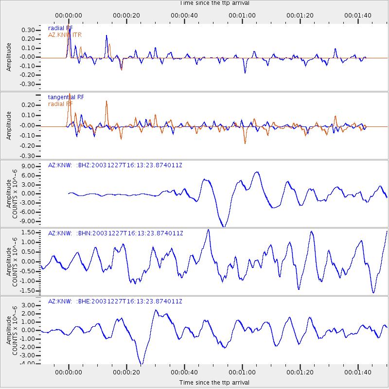
Earthquake location: Southeast Of Loyalty Islands
Earthquake latitude/longitude: -22.0/169.8
Earthquake time(UTC): 2003/12/27 (361) 16:00:59 GMT
Earthquake Depth: 10 km
Earthquake Magnitude: 6.1 MB, 7.1 MS, 7.3 MW, 7.2 MW
Earthquake Catalog/Contributor: WHDF/NEIC
Network: AZ ANZA Regional Network
Station: KNW AZ.KNW
Lat/Lon: 33.71 N/116.71 W
Elevation: 1507 m
Distance: 89.2 deg
Az: 53.07 deg
Baz: 242.864 deg
Ray Param: 0.04200407
Estimated Moho Depth: 27.5 km
Estimated Crust Vp/Vs: 2.10
Assumed Crust Vp: 6.264 km/s
Estimated Crust Vs: 2.986 km/s
Estimated Crust Poisson's Ratio: 0.35
Radial Match: 92.01831 %
Radial Bump: 372
Transverse Match: 78.56544 %
Transverse Bump: 400
SOD ConfigId: 32974
Insert Time: 2010-02-26 19:29:42.282 +0000
GWidth: 2.5
Max Bumps: 400
Tol: 0.001

Signal To Noise

ChannelStoNSTALTA
AZ:KNW: :BHN:20031227T16:13:23.874011Z1.23875583.091748E-72.4958496E-7
AZ:KNW: :BHE:20031227T16:13:23.874011Z1.11669254.048573E-73.6255037E-7
AZ:KNW: :BHZ:20031227T16:13:23.874011Z2.933187.602524E-72.591905E-7
Arrivals
Ps4.9 SECOND
PpPs13 SECOND
PsPs/PpSs18 SECOND