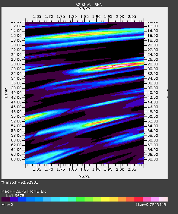
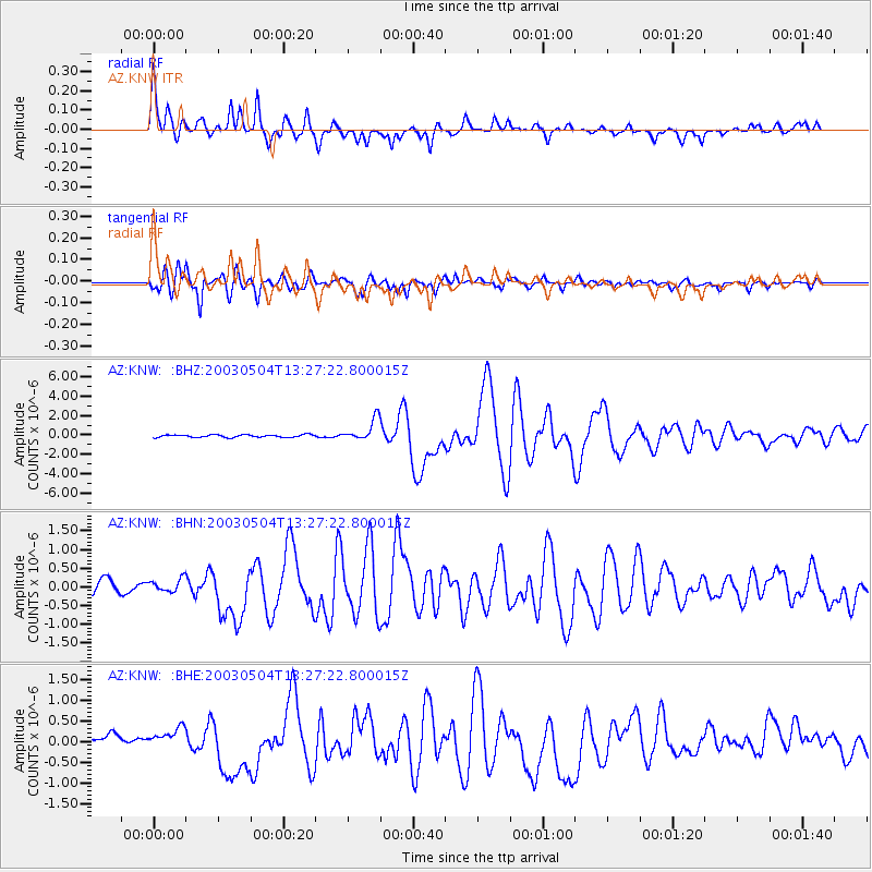
KNW AZ.KNW - Earthquake Result Viewer

Earthquake location: Kermadec Islands, New Zealand
Earthquake latitude/longitude: -30.5/-178.2
Earthquake time(UTC): 2003/05/04 (124) 13:15:18 GMT
Earthquake Depth: 62 km
Earthquake Magnitude: 6.0 MB, 6.5 MS, 6.7 MW, 6.7 MW
Earthquake Catalog/Contributor: WHDF/NEIC
Network: AZ ANZA Regional Network
Station: KNW AZ.KNW
Lat/Lon: 33.71 N/116.71 W
Elevation: 1507 m
Distance: 86.3 deg
Az: 47.236 deg
Baz: 229.461 deg
Ray Param: 0.044002347
Estimated Moho Depth: 28.75 km
Estimated Crust Vp/Vs: 1.97
Assumed Crust Vp: 6.264 km/s
Estimated Crust Vs: 3.184 km/s
Estimated Crust Poisson's Ratio: 0.33
Radial Match: 92.92361 %
Radial Bump: 400
Transverse Match: 87.7063 %
Transverse Bump: 400
SOD ConfigId: 32974
Insert Time: 2010-02-26 19:30:03.593 +0000
GWidth: 2.5
Max Bumps: 400
Tol: 0.001

Signal To Noise

ChannelStoNSTALTA
AZ:KNW: :BHN:20030504T13:27:22.800015Z0.979662841.7775668E-71.814468E-7
AZ:KNW: :BHE:20030504T13:27:22.800015Z1.41655392.4884244E-71.756675E-7
AZ:KNW: :BHZ:20030504T13:27:22.800015Z8.4208451.1310909E-61.3432036E-7
Arrivals
Ps4.5 SECOND
PpPs13 SECOND
PsPs/PpSs18 SECOND