You are here: Home > Network List > AZ - ANZA Regional Network Stations List
> Station KNW AZ.KNW > Earthquake Result Viewer
KNW AZ.KNW - Earthquake Result Viewer

| Earthquake location: |
Hokkaido, Japan Region |
| Earthquake latitude/longitude: |
43.0/145.1 |
| Earthquake time(UTC): |
2004/11/28 (333) 18:32:14 GMT |
| Earthquake Depth: |
39 km |
| Earthquake Magnitude: |
6.4 MB, 6.7 MS, 7.0 MW, 7.0 MW |
| Earthquake Catalog/Contributor: |
WHDF/NEIC |
|
| Network: |
AZ ANZA Regional Network |
| Station: |
KNW AZ.KNW |
| Lat/Lon: |
33.71 N/116.71 W |
| Elevation: |
1507 m |
|
| Distance: |
73.2 deg |
| Az: |
59.512 deg |
| Baz: |
310.678 deg |
| Ray Param: |
0.05308046 |
| Estimated Moho Depth: |
34.25 km |
| Estimated Crust Vp/Vs: |
1.69 |
| Assumed Crust Vp: |
6.264 km/s |
| Estimated Crust Vs: |
3.706 km/s |
| Estimated Crust Poisson's Ratio: |
0.23 |
|
| Radial Match: |
93.75586 % |
| Radial Bump: |
400 |
| Transverse Match: |
77.30998 % |
| Transverse Bump: |
400 |
| SOD ConfigId: |
2459 |
| Insert Time: |
2010-02-26 19:30:15.905 +0000 |
| GWidth: |
2.5 |
| Max Bumps: |
400 |
| Tol: |
0.001 |
|
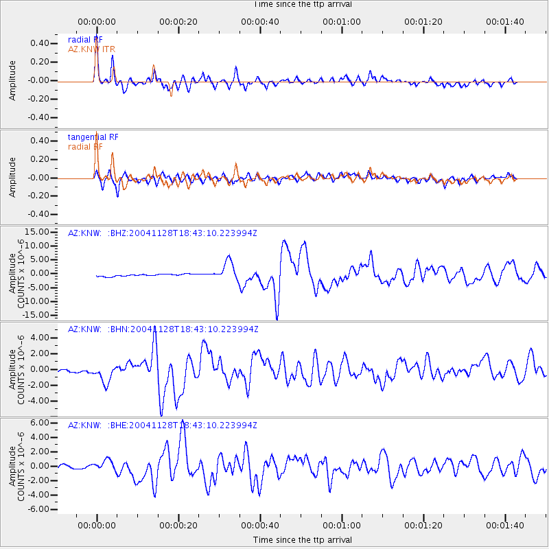
Signal To Noise
| Channel | StoN | STA | LTA |
| AZ:KNW: :BHN:20041128T18:43:10.223994Z | 1.8620232 | 1.545193E-6 | 8.298462E-7 |
| AZ:KNW: :BHE:20041128T18:43:10.223994Z | 2.7796926 | 8.76226E-7 | 3.1522407E-7 |
| AZ:KNW: :BHZ:20041128T18:43:10.223994Z | 9.205649 | 3.6042197E-6 | 3.915226E-7 |
| Arrivals |
| Ps | 3.9 SECOND |
| PpPs | 14 SECOND |
| PsPs/PpSs | 18 SECOND |


