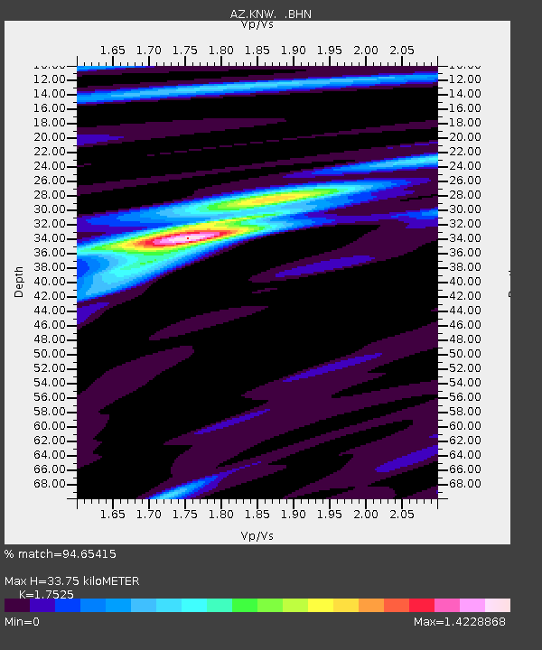
KNW AZ.KNW - Earthquake Result Viewer

Earthquake location: Near S. Coast Of Western Honshu
Earthquake latitude/longitude: 33.1/136.6
Earthquake time(UTC): 2004/09/05 (249) 10:07:07 GMT
Earthquake Depth: 14 km
Earthquake Magnitude: 6.7 MB, 7.0 MS, 7.2 MW, 7.0 MW
Earthquake Catalog/Contributor: WHDF/NEIC
Network: AZ ANZA Regional Network
Station: KNW AZ.KNW
Lat/Lon: 33.71 N/116.71 W
Elevation: 1507 m
Distance: 84.3 deg
Az: 53.366 deg
Baz: 306.062 deg
Ray Param: 0.04557281
Estimated Moho Depth: 33.75 km
Estimated Crust Vp/Vs: 1.75
Assumed Crust Vp: 6.264 km/s
Estimated Crust Vs: 3.574 km/s
Estimated Crust Poisson's Ratio: 0.26
Radial Match: 94.65415 %
Radial Bump: 369
Transverse Match: 91.478165 %
Transverse Bump: 400
SOD ConfigId: 2459
Insert Time: 2010-02-26 19:30:29.706 +0000
GWidth: 2.5
Max Bumps: 400
Tol: 0.001

Signal To Noise

ChannelStoNSTALTA
AZ:KNW: :BHN:20040905T10:19:07.650017Z6.8103262.3773734E-63.4908365E-7
AZ:KNW: :BHE:20040905T10:19:07.650017Z11.9028642.5131083E-62.1113475E-7
AZ:KNW: :BHZ:20040905T10:19:07.650017Z48.4799581.1229053E-52.3162258E-7
Arrivals
Ps4.2 SECOND
PpPs14 SECOND
PsPs/PpSs19 SECOND