You are here: Home > Network List > TA - USArray Transportable Network (new EarthScope stations) Stations List
> Station B32A Ashes, Strandquist, MN, USA > Earthquake Result Viewer
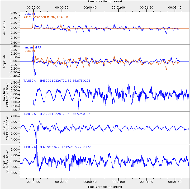
B32A Ashes, Strandquist, MN, USA - Earthquake Result Viewer
*The percent match for this event was below the threshold and hence no stack was calculated.
| Earthquake location: |
Near East Coast Of Kamchatka |
| Earthquake latitude/longitude: |
55.9/162.1 |
| Earthquake time(UTC): |
2011/02/20 (051) 21:43:24 GMT |
| Earthquake Depth: |
33 km |
| Earthquake Magnitude: |
6.1 MB, 5.9 MS, 6.2 MW, 5.9 MW |
| Earthquake Catalog/Contributor: |
WHDF/NEIC |
|
| Network: |
TA USArray Transportable Network (new EarthScope stations) |
| Station: |
B32A Ashes, Strandquist, MN, USA |
| Lat/Lon: |
48.40 N/96.54 W |
| Elevation: |
335 m |
|
| Distance: |
57.2 deg |
| Az: |
51.057 deg |
| Baz: |
318.931 deg |
| Ray Param: |
$rayparam |
*The percent match for this event was below the threshold and hence was not used in the summary stack. |
|
| Radial Match: |
66.828545 % |
| Radial Bump: |
400 |
| Transverse Match: |
69.193436 % |
| Transverse Bump: |
400 |
| SOD ConfigId: |
353373 |
| Insert Time: |
2011-07-30 10:37:04.813 +0000 |
| GWidth: |
2.5 |
| Max Bumps: |
400 |
| Tol: |
0.001 |
|
Signal To Noise
| Channel | StoN | STA | LTA |
| TA:B32A: :BHZ:20110220T21:52:36.975012Z | 2.9162736 | 1.93694E-6 | 6.641832E-7 |
| TA:B32A: :BHN:20110220T21:52:36.975012Z | 2.0327919 | 1.0699825E-6 | 5.263611E-7 |
| TA:B32A: :BHE:20110220T21:52:36.975012Z | 1.2170386 | 6.910444E-7 | 5.678081E-7 |
| Arrivals |
| Ps | |
| PpPs | |
| PsPs/PpSs | |


