You are here: Home > Network List > TA - USArray Transportable Network (new EarthScope stations) Stations List
> Station G31A Conde, SD, USA > Earthquake Result Viewer
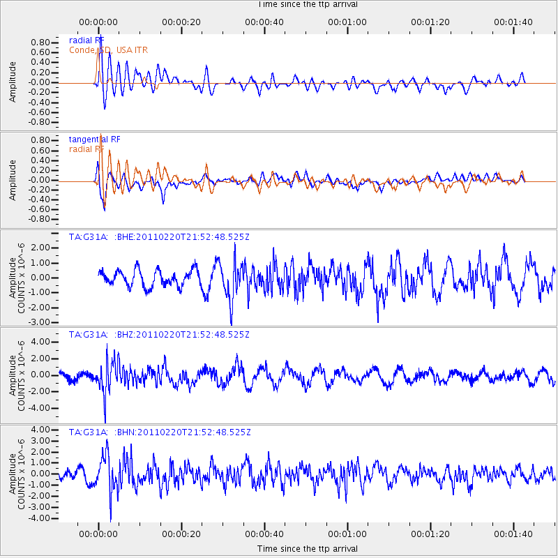
G31A Conde, SD, USA - Earthquake Result Viewer
*The percent match for this event was below the threshold and hence no stack was calculated.
| Earthquake location: |
Near East Coast Of Kamchatka |
| Earthquake latitude/longitude: |
55.9/162.1 |
| Earthquake time(UTC): |
2011/02/20 (051) 21:43:24 GMT |
| Earthquake Depth: |
33 km |
| Earthquake Magnitude: |
6.1 MB, 5.9 MS, 6.2 MW, 5.9 MW |
| Earthquake Catalog/Contributor: |
WHDF/NEIC |
|
| Network: |
TA USArray Transportable Network (new EarthScope stations) |
| Station: |
G31A Conde, SD, USA |
| Lat/Lon: |
45.23 N/98.21 W |
| Elevation: |
393 m |
|
| Distance: |
58.8 deg |
| Az: |
54.525 deg |
| Baz: |
319.554 deg |
| Ray Param: |
$rayparam |
*The percent match for this event was below the threshold and hence was not used in the summary stack. |
|
| Radial Match: |
63.170605 % |
| Radial Bump: |
400 |
| Transverse Match: |
74.87201 % |
| Transverse Bump: |
400 |
| SOD ConfigId: |
353373 |
| Insert Time: |
2011-07-30 10:46:35.267 +0000 |
| GWidth: |
2.5 |
| Max Bumps: |
400 |
| Tol: |
0.001 |
|
Signal To Noise
| Channel | StoN | STA | LTA |
| TA:G31A: :BHZ:20110220T21:52:48.525Z | 3.4778347 | 1.9481545E-6 | 5.60163E-7 |
| TA:G31A: :BHN:20110220T21:52:48.525Z | 2.5076287 | 1.6482303E-6 | 6.572864E-7 |
| TA:G31A: :BHE:20110220T21:52:48.525Z | 2.4181468 | 1.2795377E-6 | 5.291398E-7 |
| Arrivals |
| Ps | |
| PpPs | |
| PsPs/PpSs | |


