You are here: Home > Network List > US - United States National Seismic Network Stations List
> Station EYMN Ely, Minnesota, USA > Earthquake Result Viewer
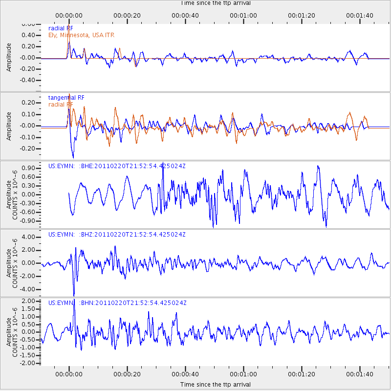
EYMN Ely, Minnesota, USA - Earthquake Result Viewer
*The percent match for this event was below the threshold and hence no stack was calculated.
| Earthquake location: |
Near East Coast Of Kamchatka |
| Earthquake latitude/longitude: |
55.9/162.1 |
| Earthquake time(UTC): |
2011/02/20 (051) 21:43:24 GMT |
| Earthquake Depth: |
33 km |
| Earthquake Magnitude: |
6.1 MB, 5.9 MS, 6.2 MW, 5.9 MW |
| Earthquake Catalog/Contributor: |
WHDF/NEIC |
|
| Network: |
US United States National Seismic Network |
| Station: |
EYMN Ely, Minnesota, USA |
| Lat/Lon: |
47.95 N/91.50 W |
| Elevation: |
475 m |
|
| Distance: |
59.7 deg |
| Az: |
48.357 deg |
| Baz: |
321.262 deg |
| Ray Param: |
$rayparam |
*The percent match for this event was below the threshold and hence was not used in the summary stack. |
|
| Radial Match: |
67.8483 % |
| Radial Bump: |
400 |
| Transverse Match: |
67.259544 % |
| Transverse Bump: |
400 |
| SOD ConfigId: |
353373 |
| Insert Time: |
2011-07-30 11:45:42.845 +0000 |
| GWidth: |
2.5 |
| Max Bumps: |
400 |
| Tol: |
0.001 |
|
Signal To Noise
| Channel | StoN | STA | LTA |
| US:EYMN: :BHZ:20110220T21:52:54.425024Z | 5.1441064 | 1.7978774E-6 | 3.4950236E-7 |
| US:EYMN: :BHN:20110220T21:52:54.425024Z | 1.7803934 | 7.097662E-7 | 3.9865697E-7 |
| US:EYMN: :BHE:20110220T21:52:54.425024Z | 1.5042876 | 4.595728E-7 | 3.055086E-7 |
| Arrivals |
| Ps | |
| PpPs | |
| PsPs/PpSs | |


