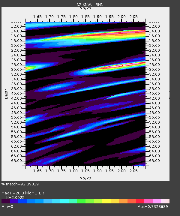
KNW AZ.KNW - Earthquake Result Viewer
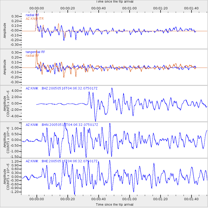
Earthquake location: South Of Kermadec Islands
Earthquake latitude/longitude: -32.6/-179.4
Earthquake time(UTC): 2005/05/16 (136) 03:54:14 GMT
Earthquake Depth: 34 km
Earthquake Magnitude: 6.2 MB, 6.4 MS, 6.6 MW, 6.6 MW
Earthquake Catalog/Contributor: WHDF/NEIC
Network: AZ ANZA Regional Network
Station: KNW AZ.KNW
Lat/Lon: 33.71 N/116.71 W
Elevation: 1507 m
Distance: 88.4 deg
Az: 47.78 deg
Baz: 228.594 deg
Ray Param: 0.04254108
Estimated Moho Depth: 28.0 km
Estimated Crust Vp/Vs: 2.00
Assumed Crust Vp: 6.264 km/s
Estimated Crust Vs: 3.128 km/s
Estimated Crust Poisson's Ratio: 0.33
Radial Match: 92.89029 %
Radial Bump: 400
Transverse Match: 80.91142 %
Transverse Bump: 400
SOD ConfigId: 32974
Insert Time: 2010-02-26 19:30:52.679 +0000
GWidth: 2.5
Max Bumps: 400
Tol: 0.001

Signal To Noise

ChannelStoNSTALTA
AZ:KNW: :BHN:20050516T04:06:32.075017Z1.56731332.1362804E-71.3630206E-7
AZ:KNW: :BHE:20050516T04:06:32.075017Z2.5137192.5894417E-71.0301237E-7
AZ:KNW: :BHZ:20050516T04:06:32.075017Z12.5544311.3727789E-61.0934617E-7
Arrivals
Ps4.6 SECOND
PpPs13 SECOND
PsPs/PpSs18 SECOND