You are here: Home > Network List > US - United States National Seismic Network Stations List
> Station COWI Conover, Wisconsin, USA > Earthquake Result Viewer
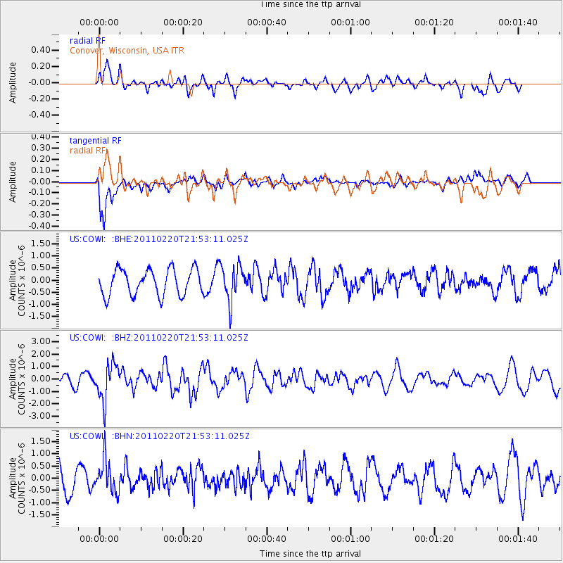
COWI Conover, Wisconsin, USA - Earthquake Result Viewer
*The percent match for this event was below the threshold and hence no stack was calculated.
| Earthquake location: |
Near East Coast Of Kamchatka |
| Earthquake latitude/longitude: |
55.9/162.1 |
| Earthquake time(UTC): |
2011/02/20 (051) 21:43:24 GMT |
| Earthquake Depth: |
33 km |
| Earthquake Magnitude: |
6.1 MB, 5.9 MS, 6.2 MW, 5.9 MW |
| Earthquake Catalog/Contributor: |
WHDF/NEIC |
|
| Network: |
US United States National Seismic Network |
| Station: |
COWI Conover, Wisconsin, USA |
| Lat/Lon: |
46.10 N/89.14 W |
| Elevation: |
523 m |
|
| Distance: |
62.1 deg |
| Az: |
48.199 deg |
| Baz: |
322.905 deg |
| Ray Param: |
$rayparam |
*The percent match for this event was below the threshold and hence was not used in the summary stack. |
|
| Radial Match: |
68.43684 % |
| Radial Bump: |
400 |
| Transverse Match: |
69.762085 % |
| Transverse Bump: |
400 |
| SOD ConfigId: |
353373 |
| Insert Time: |
2011-07-30 12:08:20.639 +0000 |
| GWidth: |
2.5 |
| Max Bumps: |
400 |
| Tol: |
0.001 |
|
Signal To Noise
| Channel | StoN | STA | LTA |
| US:COWI: :BHZ:20110220T21:53:11.025Z | 2.0416706 | 1.4951161E-6 | 7.323003E-7 |
| US:COWI: :BHN:20110220T21:53:11.025Z | 1.4091046 | 6.716294E-7 | 4.766356E-7 |
| US:COWI: :BHE:20110220T21:53:11.025Z | 1.3579924 | 7.264192E-7 | 5.349214E-7 |
| Arrivals |
| Ps | |
| PpPs | |
| PsPs/PpSs | |


