You are here: Home > Network List > UW - Pacific Northwest Regional Seismic Network Stations List
> Station HOOD Mt Hood Meadows, OR CREST BB SMO > Earthquake Result Viewer
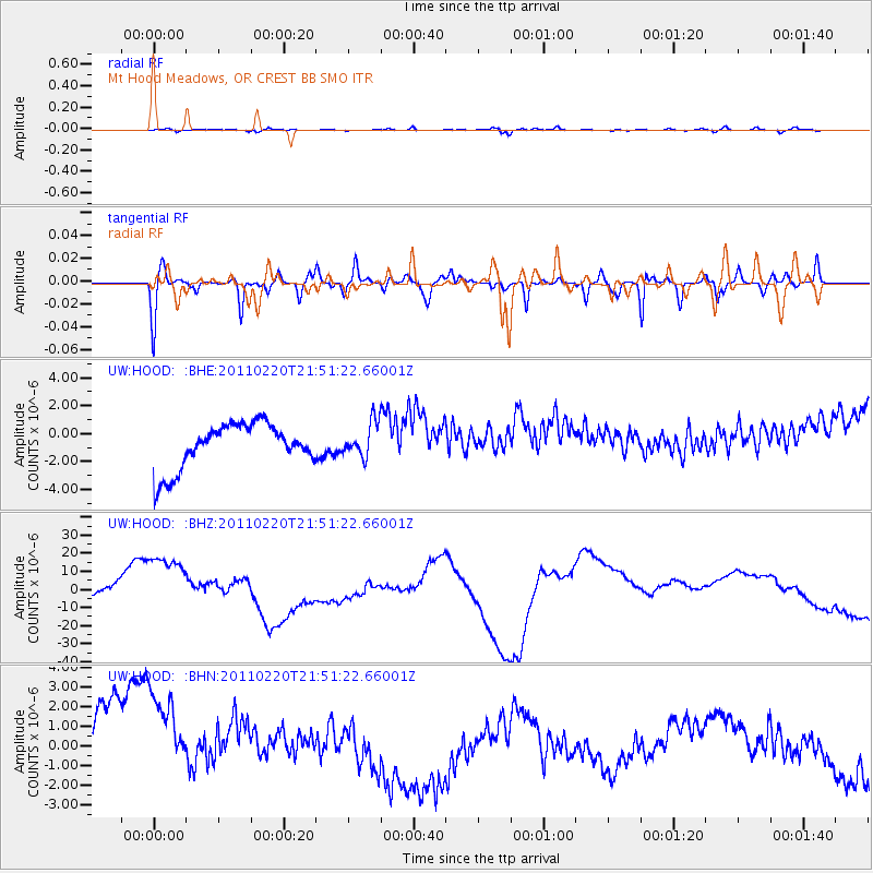
HOOD Mt Hood Meadows, OR CREST BB SMO - Earthquake Result Viewer
*The percent match for this event was below the threshold and hence no stack was calculated.
| Earthquake location: |
Near East Coast Of Kamchatka |
| Earthquake latitude/longitude: |
55.9/162.1 |
| Earthquake time(UTC): |
2011/02/20 (051) 21:43:24 GMT |
| Earthquake Depth: |
33 km |
| Earthquake Magnitude: |
6.1 MB, 5.9 MS, 6.2 MW, 5.9 MW |
| Earthquake Catalog/Contributor: |
WHDF/NEIC |
|
| Network: |
UW Pacific Northwest Regional Seismic Network |
| Station: |
HOOD Mt Hood Meadows, OR CREST BB SMO |
| Lat/Lon: |
45.32 N/121.65 W |
| Elevation: |
1520 m |
|
| Distance: |
47.1 deg |
| Az: |
69.209 deg |
| Baz: |
311.756 deg |
| Ray Param: |
$rayparam |
*The percent match for this event was below the threshold and hence was not used in the summary stack. |
|
| Radial Match: |
21.892038 % |
| Radial Bump: |
400 |
| Transverse Match: |
46.55468 % |
| Transverse Bump: |
336 |
| SOD ConfigId: |
353373 |
| Insert Time: |
2011-07-30 12:12:40.444 +0000 |
| GWidth: |
2.5 |
| Max Bumps: |
400 |
| Tol: |
0.001 |
|
Signal To Noise
| Channel | StoN | STA | LTA |
| UW:HOOD: :BHZ:20110220T21:51:22.66001Z | 4.035024 | 2.0902356E-5 | 5.180231E-6 |
| UW:HOOD: :BHN:20110220T21:51:22.66001Z | 1.0416356 | 2.9911932E-6 | 2.871631E-6 |
| UW:HOOD: :BHE:20110220T21:51:22.66001Z | 0.7514686 | 1.2080549E-6 | 1.6075919E-6 |
| Arrivals |
| Ps | |
| PpPs | |
| PsPs/PpSs | |


