You are here: Home > Network List > UW - Pacific Northwest Regional Seismic Network Stations List
> Station MRBL Marblemount, WA, USA > Earthquake Result Viewer
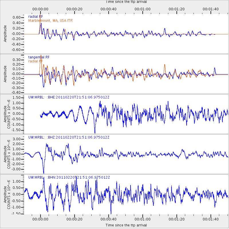
MRBL Marblemount, WA, USA - Earthquake Result Viewer
*The percent match for this event was below the threshold and hence no stack was calculated.
| Earthquake location: |
Near East Coast Of Kamchatka |
| Earthquake latitude/longitude: |
55.9/162.1 |
| Earthquake time(UTC): |
2011/02/20 (051) 21:43:24 GMT |
| Earthquake Depth: |
33 km |
| Earthquake Magnitude: |
6.1 MB, 5.9 MS, 6.2 MW, 5.9 MW |
| Earthquake Catalog/Contributor: |
WHDF/NEIC |
|
| Network: |
UW Pacific Northwest Regional Seismic Network |
| Station: |
MRBL Marblemount, WA, USA |
| Lat/Lon: |
48.52 N/121.48 W |
| Elevation: |
75 m |
|
| Distance: |
45.1 deg |
| Az: |
65.737 deg |
| Baz: |
309.473 deg |
| Ray Param: |
$rayparam |
*The percent match for this event was below the threshold and hence was not used in the summary stack. |
|
| Radial Match: |
65.1232 % |
| Radial Bump: |
400 |
| Transverse Match: |
69.29232 % |
| Transverse Bump: |
400 |
| SOD ConfigId: |
353373 |
| Insert Time: |
2011-07-30 12:14:25.904 +0000 |
| GWidth: |
2.5 |
| Max Bumps: |
400 |
| Tol: |
0.001 |
|
Signal To Noise
| Channel | StoN | STA | LTA |
| UW:MRBL: :BHZ:20110220T21:51:06.975012Z | 10.076127 | 1.5514587E-6 | 1.5397372E-7 |
| UW:MRBL: :BHN:20110220T21:51:06.975012Z | 2.9764044 | 6.399592E-7 | 2.1501083E-7 |
| UW:MRBL: :BHE:20110220T21:51:06.975012Z | 2.3843799 | 6.728895E-7 | 2.822073E-7 |
| Arrivals |
| Ps | |
| PpPs | |
| PsPs/PpSs | |


