You are here: Home > Network List > CI - Caltech Regional Seismic Network Stations List
> Station SMM Simmler, CA, USA > Earthquake Result Viewer
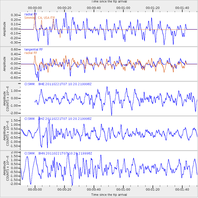
SMM Simmler, CA, USA - Earthquake Result Viewer
*The percent match for this event was below the threshold and hence no stack was calculated.
| Earthquake location: |
Santiago Del Estero Prov., Arg. |
| Earthquake latitude/longitude: |
-27.1/-64.7 |
| Earthquake time(UTC): |
2011/02/21 (052) 06:58:36 GMT |
| Earthquake Depth: |
13 km |
| Earthquake Magnitude: |
6.0 MB, 5.4 MS, 5.6 MW, 5.5 MW |
| Earthquake Catalog/Contributor: |
WHDF/NEIC |
|
| Network: |
CI Caltech Regional Seismic Network |
| Station: |
SMM Simmler, CA, USA |
| Lat/Lon: |
35.31 N/120.00 W |
| Elevation: |
599 m |
|
| Distance: |
81.2 deg |
| Az: |
317.117 deg |
| Baz: |
132.145 deg |
| Ray Param: |
$rayparam |
*The percent match for this event was below the threshold and hence was not used in the summary stack. |
|
| Radial Match: |
44.509228 % |
| Radial Bump: |
400 |
| Transverse Match: |
56.008087 % |
| Transverse Bump: |
400 |
| SOD ConfigId: |
353373 |
| Insert Time: |
2011-07-30 12:41:57.681 +0000 |
| GWidth: |
2.5 |
| Max Bumps: |
400 |
| Tol: |
0.001 |
|
Signal To Noise
| Channel | StoN | STA | LTA |
| CI:SMM: :BHZ:20110221T07:10:20.219998Z | 3.2515438 | 8.821947E-7 | 2.7131563E-7 |
| CI:SMM: :BHN:20110221T07:10:20.219998Z | 1.465856 | 8.980525E-7 | 6.1264717E-7 |
| CI:SMM: :BHE:20110221T07:10:20.219998Z | 1.0041425 | 4.4315541E-7 | 4.413272E-7 |
| Arrivals |
| Ps | |
| PpPs | |
| PsPs/PpSs | |


