You are here: Home > Network List > TA - USArray Transportable Network (new EarthScope stations) Stations List
> Station V34A Guthrie, OK, USA > Earthquake Result Viewer
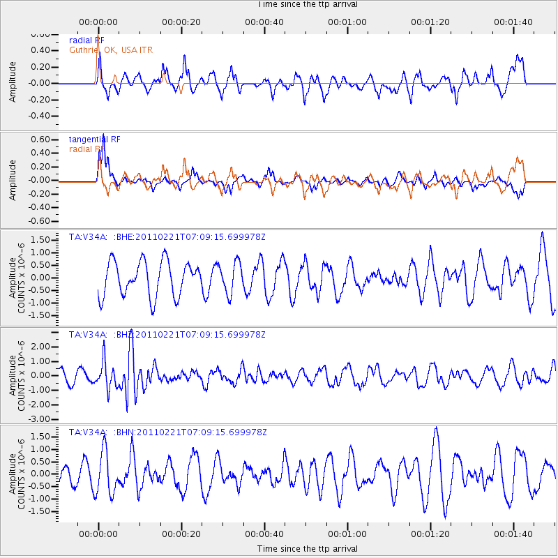
V34A Guthrie, OK, USA - Earthquake Result Viewer
*The percent match for this event was below the threshold and hence no stack was calculated.
| Earthquake location: |
Santiago Del Estero Prov., Arg. |
| Earthquake latitude/longitude: |
-27.1/-64.7 |
| Earthquake time(UTC): |
2011/02/21 (052) 06:58:36 GMT |
| Earthquake Depth: |
13 km |
| Earthquake Magnitude: |
6.0 MB, 5.4 MS, 5.6 MW, 5.5 MW |
| Earthquake Catalog/Contributor: |
WHDF/NEIC |
|
| Network: |
TA USArray Transportable Network (new EarthScope stations) |
| Station: |
V34A Guthrie, OK, USA |
| Lat/Lon: |
35.83 N/97.52 W |
| Elevation: |
329 m |
|
| Distance: |
69.9 deg |
| Az: |
332.022 deg |
| Baz: |
149.039 deg |
| Ray Param: |
$rayparam |
*The percent match for this event was below the threshold and hence was not used in the summary stack. |
|
| Radial Match: |
64.46259 % |
| Radial Bump: |
377 |
| Transverse Match: |
69.64482 % |
| Transverse Bump: |
251 |
| SOD ConfigId: |
353373 |
| Insert Time: |
2011-07-30 13:56:37.145 +0000 |
| GWidth: |
2.5 |
| Max Bumps: |
400 |
| Tol: |
0.001 |
|
Signal To Noise
| Channel | StoN | STA | LTA |
| TA:V34A: :BHZ:20110221T07:09:15.699978Z | 3.2040248 | 9.191986E-7 | 2.8688873E-7 |
| TA:V34A: :BHN:20110221T07:09:15.699978Z | 1.1855199 | 8.704508E-7 | 7.342355E-7 |
| TA:V34A: :BHE:20110221T07:09:15.699978Z | 0.888101 | 6.127886E-7 | 6.899988E-7 |
| Arrivals |
| Ps | |
| PpPs | |
| PsPs/PpSs | |


