You are here: Home > Network List > TA - USArray Transportable Network (new EarthScope stations) Stations List
> Station D57A Chemin Vers le Barrage, Saint-Michel-Des-Saints, Q > Earthquake Result Viewer
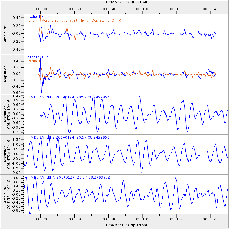
D57A Chemin Vers le Barrage, Saint-Michel-Des-Saints, Q - Earthquake Result Viewer
*The percent match for this event was below the threshold and hence no stack was calculated.
| Earthquake location: |
Kuril Islands |
| Earthquake latitude/longitude: |
48.7/155.3 |
| Earthquake time(UTC): |
2014/01/24 (024) 20:46:01 GMT |
| Earthquake Depth: |
64 km |
| Earthquake Magnitude: |
4.2 mb |
| Earthquake Catalog/Contributor: |
ISC/ISC |
|
| Network: |
TA USArray Transportable Network (new EarthScope stations) |
| Station: |
D57A Chemin Vers le Barrage, Saint-Michel-Des-Saints, Q |
| Lat/Lon: |
47.02 N/73.89 W |
| Elevation: |
422 m |
|
| Distance: |
75.5 deg |
| Az: |
32.35 deg |
| Baz: |
328.827 deg |
| Ray Param: |
$rayparam |
*The percent match for this event was below the threshold and hence was not used in the summary stack. |
|
| Radial Match: |
66.26385 % |
| Radial Bump: |
400 |
| Transverse Match: |
75.44438 % |
| Transverse Bump: |
400 |
| SOD ConfigId: |
3390531 |
| Insert Time: |
2019-04-10 02:29:24.705 +0000 |
| GWidth: |
2.5 |
| Max Bumps: |
400 |
| Tol: |
0.001 |
|
Signal To Noise
| Channel | StoN | STA | LTA |
| TA:D57A: :BHZ:20140124T20:57:08.249995Z | 2.0320652 | 1.2792657E-6 | 6.2953967E-7 |
| TA:D57A: :BHN:20140124T20:57:08.249995Z | 1.429955 | 5.0584E-7 | 3.5374538E-7 |
| TA:D57A: :BHE:20140124T20:57:08.249995Z | 1.4589882 | 8.1846576E-7 | 5.609818E-7 |
| Arrivals |
| Ps | |
| PpPs | |
| PsPs/PpSs | |


