You are here: Home > Network List > TA - USArray Transportable Network (new EarthScope stations) Stations List
> Station I64A Boothbay, ME, USA > Earthquake Result Viewer
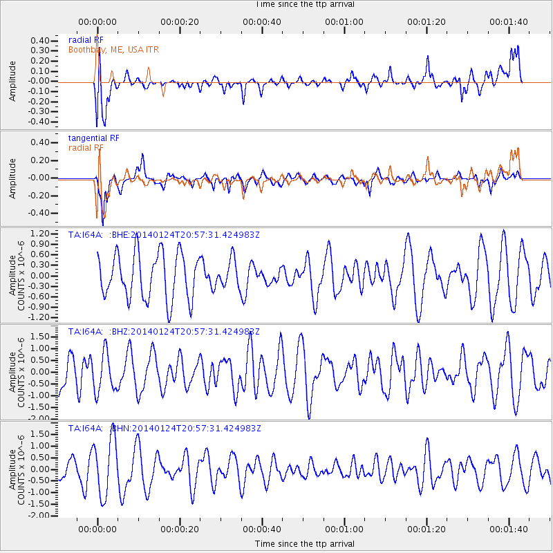
I64A Boothbay, ME, USA - Earthquake Result Viewer
*The percent match for this event was below the threshold and hence no stack was calculated.
| Earthquake location: |
Kuril Islands |
| Earthquake latitude/longitude: |
48.7/155.3 |
| Earthquake time(UTC): |
2014/01/24 (024) 20:46:01 GMT |
| Earthquake Depth: |
64 km |
| Earthquake Magnitude: |
4.2 mb |
| Earthquake Catalog/Contributor: |
ISC/ISC |
|
| Network: |
TA USArray Transportable Network (new EarthScope stations) |
| Station: |
I64A Boothbay, ME, USA |
| Lat/Lon: |
43.92 N/69.63 W |
| Elevation: |
17 m |
|
| Distance: |
79.7 deg |
| Az: |
31.264 deg |
| Baz: |
331.617 deg |
| Ray Param: |
$rayparam |
*The percent match for this event was below the threshold and hence was not used in the summary stack. |
|
| Radial Match: |
64.35693 % |
| Radial Bump: |
400 |
| Transverse Match: |
74.26499 % |
| Transverse Bump: |
400 |
| SOD ConfigId: |
3390531 |
| Insert Time: |
2019-04-10 02:29:43.079 +0000 |
| GWidth: |
2.5 |
| Max Bumps: |
400 |
| Tol: |
0.001 |
|
Signal To Noise
| Channel | StoN | STA | LTA |
| TA:I64A: :BHZ:20140124T20:57:31.424983Z | 1.3437269 | 8.537052E-7 | 6.353264E-7 |
| TA:I64A: :BHN:20140124T20:57:31.424983Z | 1.6953179 | 1.2486244E-6 | 7.365134E-7 |
| TA:I64A: :BHE:20140124T20:57:31.424983Z | 0.60694844 | 3.9750145E-7 | 6.549179E-7 |
| Arrivals |
| Ps | |
| PpPs | |
| PsPs/PpSs | |


