You are here: Home > Network List > TA - USArray Transportable Network (new EarthScope stations) Stations List
> Station 139A Bunkhouse Ranch, Marshall, TX, USA > Earthquake Result Viewer
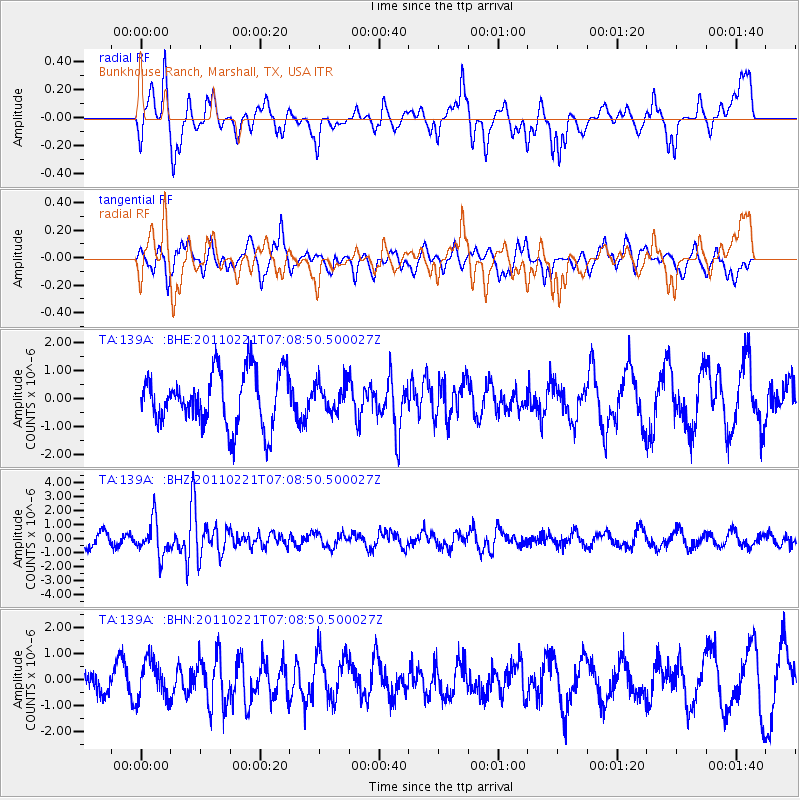
139A Bunkhouse Ranch, Marshall, TX, USA - Earthquake Result Viewer
*The percent match for this event was below the threshold and hence no stack was calculated.
| Earthquake location: |
Santiago Del Estero Prov., Arg. |
| Earthquake latitude/longitude: |
-27.1/-64.7 |
| Earthquake time(UTC): |
2011/02/21 (052) 06:58:36 GMT |
| Earthquake Depth: |
13 km |
| Earthquake Magnitude: |
6.0 MB, 5.4 MS, 5.6 MW, 5.5 MW |
| Earthquake Catalog/Contributor: |
WHDF/NEIC |
|
| Network: |
TA USArray Transportable Network (new EarthScope stations) |
| Station: |
139A Bunkhouse Ranch, Marshall, TX, USA |
| Lat/Lon: |
32.68 N/94.39 W |
| Elevation: |
59 m |
|
| Distance: |
65.9 deg |
| Az: |
332.747 deg |
| Baz: |
151.064 deg |
| Ray Param: |
$rayparam |
*The percent match for this event was below the threshold and hence was not used in the summary stack. |
|
| Radial Match: |
64.79311 % |
| Radial Bump: |
353 |
| Transverse Match: |
53.014683 % |
| Transverse Bump: |
388 |
| SOD ConfigId: |
353373 |
| Insert Time: |
2011-07-30 14:33:14.678 +0000 |
| GWidth: |
2.5 |
| Max Bumps: |
400 |
| Tol: |
0.001 |
|
Signal To Noise
| Channel | StoN | STA | LTA |
| TA:139A: :BHZ:20110221T07:08:50.500027Z | 2.4141445 | 1.227105E-6 | 5.082981E-7 |
| TA:139A: :BHN:20110221T07:08:50.500027Z | 1.2988844 | 7.3773674E-7 | 5.6797717E-7 |
| TA:139A: :BHE:20110221T07:08:50.500027Z | 0.52426916 | 5.022777E-7 | 9.580531E-7 |
| Arrivals |
| Ps | |
| PpPs | |
| PsPs/PpSs | |


