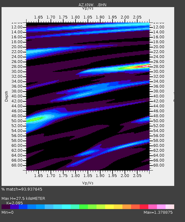
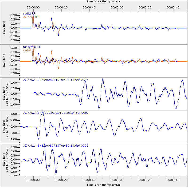
KNW AZ.KNW - Earthquake Result Viewer

Earthquake location: Santa Cruz Islands Region
Earthquake latitude/longitude: -11.0/164.5
Earthquake time(UTC): 2008/07/19 (201) 09:27:01 GMT
Earthquake Depth: 11 km
Earthquake Magnitude: 6.1 MB, 6.4 MS, 6.6 MW, 6.6 MW
Earthquake Catalog/Contributor: WHDF/NEIC
Network: AZ ANZA Regional Network
Station: KNW AZ.KNW
Lat/Lon: 33.71 N/116.71 W
Elevation: 1507 m
Distance: 86.9 deg
Az: 54.968 deg
Baz: 254.67 deg
Ray Param: 0.043704897
Estimated Moho Depth: 27.5 km
Estimated Crust Vp/Vs: 2.10
Assumed Crust Vp: 6.264 km/s
Estimated Crust Vs: 2.99 km/s
Estimated Crust Poisson's Ratio: 0.35
Radial Match: 93.937645 %
Radial Bump: 288
Transverse Match: 82.49382 %
Transverse Bump: 400
SOD ConfigId: 2658
Insert Time: 2010-02-26 19:31:33.549 +0000
GWidth: 2.5
Max Bumps: 400
Tol: 0.001

Signal To Noise

ChannelStoNSTALTA
AZ:KNW: :BHN:20080719T09:39:14.694009Z18.619421.7193507E-69.234181E-8
AZ:KNW: :BHE:20080719T09:39:14.694009Z1.53958631.3796706E-78.9613074E-8
AZ:KNW: :BHZ:20080719T09:39:14.694009Z5.33636434.544627E-78.5163364E-8
Arrivals
Ps4.9 SECOND
PpPs13 SECOND
PsPs/PpSs18 SECOND