You are here: Home > Network List > AZ - ANZA Regional Network Stations List
> Station KNW AZ.KNW > Earthquake Result Viewer
KNW AZ.KNW - Earthquake Result Viewer

| Earthquake location: |
East Of Kuril Islands |
| Earthquake latitude/longitude: |
46.9/155.2 |
| Earthquake time(UTC): |
2009/01/15 (015) 17:49:39 GMT |
| Earthquake Depth: |
36 km |
| Earthquake Magnitude: |
6.9 MB, 7.5 MS, 7.4 MW, 7.4 MW |
| Earthquake Catalog/Contributor: |
WHDF/NEIC |
|
| Network: |
AZ ANZA Regional Network |
| Station: |
KNW AZ.KNW |
| Lat/Lon: |
33.71 N/116.71 W |
| Elevation: |
1507 m |
|
| Distance: |
65.1 deg |
| Az: |
66.664 deg |
| Baz: |
310.89 deg |
| Ray Param: |
0.058408972 |
| Estimated Moho Depth: |
33.25 km |
| Estimated Crust Vp/Vs: |
1.73 |
| Assumed Crust Vp: |
6.264 km/s |
| Estimated Crust Vs: |
3.626 km/s |
| Estimated Crust Poisson's Ratio: |
0.25 |
|
| Radial Match: |
97.90359 % |
| Radial Bump: |
284 |
| Transverse Match: |
94.61376 % |
| Transverse Bump: |
400 |
| SOD ConfigId: |
2834 |
| Insert Time: |
2010-02-26 19:31:36.581 +0000 |
| GWidth: |
2.5 |
| Max Bumps: |
400 |
| Tol: |
0.001 |
|
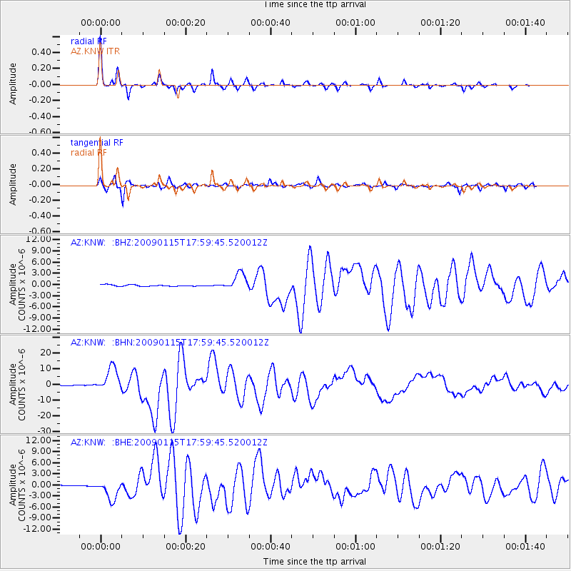
Signal To Noise
| Channel | StoN | STA | LTA |
| AZ:KNW: :BHN:20090115T17:59:45.520012Z | 44.635124 | 7.890058E-6 | 1.7676793E-7 |
| AZ:KNW: :BHE:20090115T17:59:45.520012Z | 22.333214 | 2.788194E-6 | 1.2484517E-7 |
| AZ:KNW: :BHZ:20090115T17:59:45.520012Z | 11.684829 | 2.3640914E-6 | 2.0232144E-7 |
| Arrivals |
| Ps | 4.0 SECOND |
| PpPs | 14 SECOND |
| PsPs/PpSs | 18 SECOND |


