You are here: Home > Network List > US - United States National Seismic Network Stations List
> Station AMTX Amarillo, Texas, USA > Earthquake Result Viewer
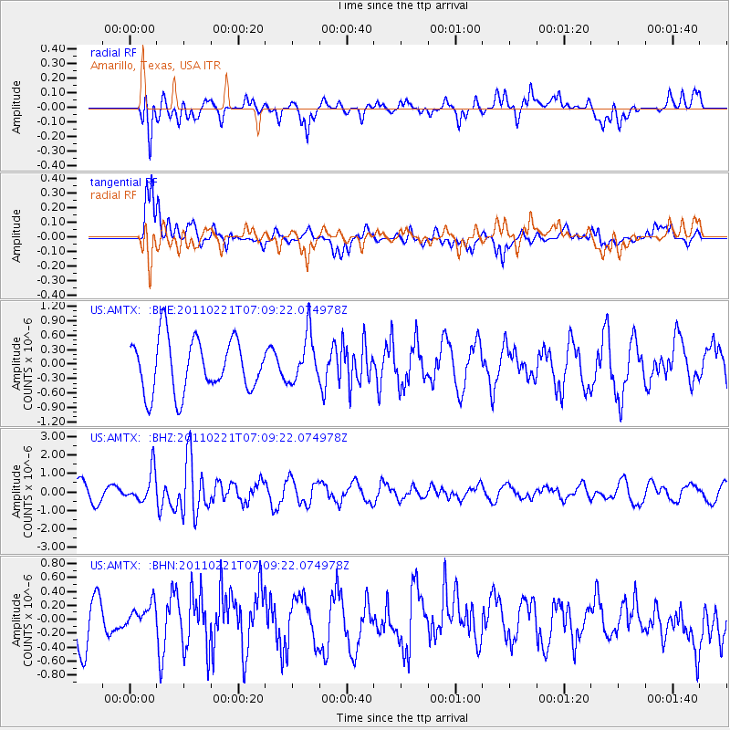
AMTX Amarillo, Texas, USA - Earthquake Result Viewer
*The percent match for this event was below the threshold and hence no stack was calculated.
| Earthquake location: |
Santiago Del Estero Prov., Arg. |
| Earthquake latitude/longitude: |
-27.1/-64.7 |
| Earthquake time(UTC): |
2011/02/21 (052) 06:58:36 GMT |
| Earthquake Depth: |
13 km |
| Earthquake Magnitude: |
6.0 MB, 5.4 MS, 5.6 MW, 5.5 MW |
| Earthquake Catalog/Contributor: |
WHDF/NEIC |
|
| Network: |
US United States National Seismic Network |
| Station: |
AMTX Amarillo, Texas, USA |
| Lat/Lon: |
34.53 N/101.41 W |
| Elevation: |
1010 m |
|
| Distance: |
70.5 deg |
| Az: |
328.424 deg |
| Baz: |
145.588 deg |
| Ray Param: |
$rayparam |
*The percent match for this event was below the threshold and hence was not used in the summary stack. |
|
| Radial Match: |
54.667473 % |
| Radial Bump: |
400 |
| Transverse Match: |
63.74616 % |
| Transverse Bump: |
400 |
| SOD ConfigId: |
353373 |
| Insert Time: |
2011-07-30 15:15:36.782 +0000 |
| GWidth: |
2.5 |
| Max Bumps: |
400 |
| Tol: |
0.001 |
|
Signal To Noise
| Channel | StoN | STA | LTA |
| US:AMTX: :BHZ:20110221T07:09:22.074978Z | 1.5346733 | 8.4255856E-7 | 5.4901494E-7 |
| US:AMTX: :BHN:20110221T07:09:22.074978Z | 0.63226384 | 1.7668937E-7 | 2.7945512E-7 |
| US:AMTX: :BHE:20110221T07:09:22.074978Z | 0.48216838 | 2.7437338E-7 | 5.690406E-7 |
| Arrivals |
| Ps | |
| PpPs | |
| PsPs/PpSs | |


