You are here: Home > Network List > UW - Pacific Northwest Regional Seismic Network Stations List
> Station MRBL Marblemount, WA, USA > Earthquake Result Viewer
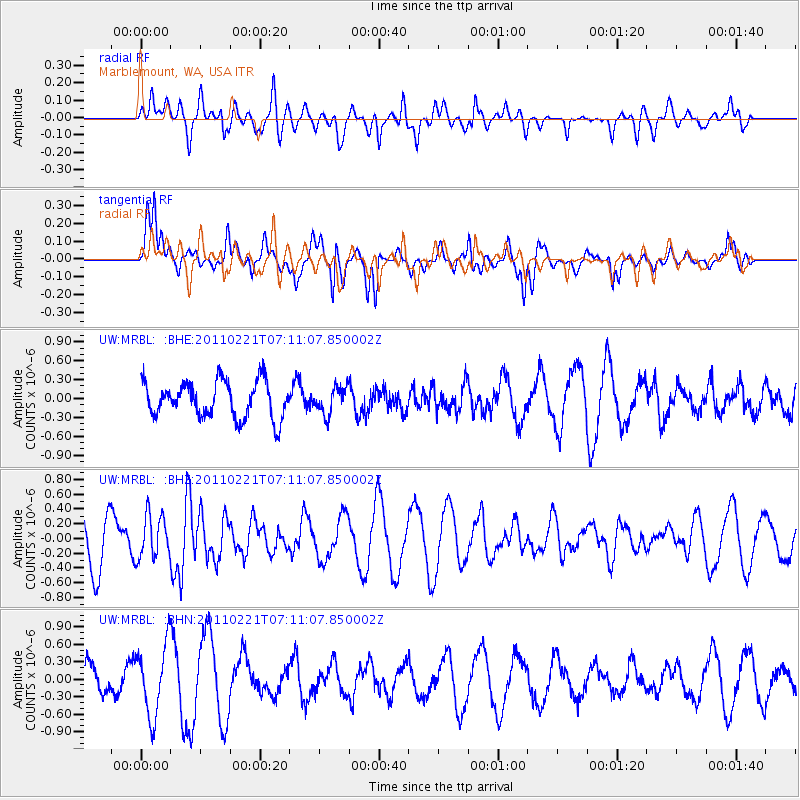
MRBL Marblemount, WA, USA - Earthquake Result Viewer
*The percent match for this event was below the threshold and hence no stack was calculated.
| Earthquake location: |
Santiago Del Estero Prov., Arg. |
| Earthquake latitude/longitude: |
-27.1/-64.7 |
| Earthquake time(UTC): |
2011/02/21 (052) 06:58:36 GMT |
| Earthquake Depth: |
13 km |
| Earthquake Magnitude: |
6.0 MB, 5.4 MS, 5.6 MW, 5.5 MW |
| Earthquake Catalog/Contributor: |
WHDF/NEIC |
|
| Network: |
UW Pacific Northwest Regional Seismic Network |
| Station: |
MRBL Marblemount, WA, USA |
| Lat/Lon: |
48.52 N/121.48 W |
| Elevation: |
75 m |
|
| Distance: |
90.8 deg |
| Az: |
326.194 deg |
| Baz: |
131.784 deg |
| Ray Param: |
$rayparam |
*The percent match for this event was below the threshold and hence was not used in the summary stack. |
|
| Radial Match: |
53.38705 % |
| Radial Bump: |
400 |
| Transverse Match: |
73.0809 % |
| Transverse Bump: |
382 |
| SOD ConfigId: |
353373 |
| Insert Time: |
2011-07-30 15:20:06.374 +0000 |
| GWidth: |
2.5 |
| Max Bumps: |
400 |
| Tol: |
0.001 |
|
Signal To Noise
| Channel | StoN | STA | LTA |
| UW:MRBL: :BHZ:20110221T07:11:07.850002Z | 0.7949472 | 2.9225643E-7 | 3.6764257E-7 |
| UW:MRBL: :BHN:20110221T07:11:07.850002Z | 3.0009894 | 6.0198533E-7 | 2.0059562E-7 |
| UW:MRBL: :BHE:20110221T07:11:07.850002Z | 0.7233147 | 2.0856463E-7 | 2.8834563E-7 |
| Arrivals |
| Ps | |
| PpPs | |
| PsPs/PpSs | |


