You are here: Home > Network List > TA - USArray Transportable Network (new EarthScope stations) Stations List
> Station R11A Troy Canyon, Currant, NV, USA > Earthquake Result Viewer
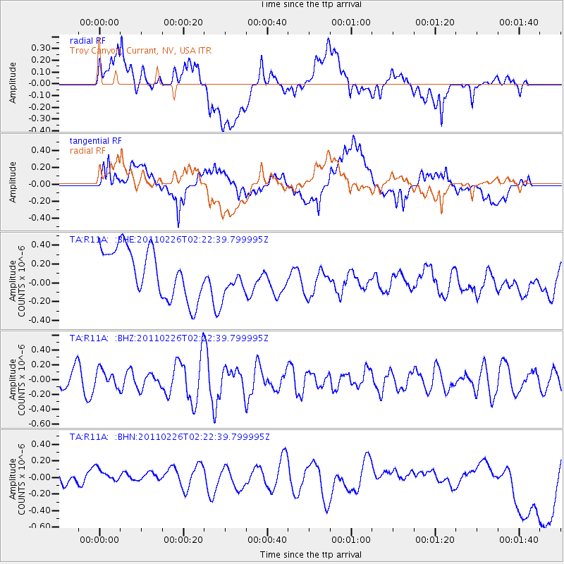
R11A Troy Canyon, Currant, NV, USA - Earthquake Result Viewer
*The percent match for this event was below the threshold and hence no stack was calculated.
| Earthquake location: |
Santa Cruz Islands Region |
| Earthquake latitude/longitude: |
-10.6/164.9 |
| Earthquake time(UTC): |
2011/02/26 (057) 02:10:24 GMT |
| Earthquake Depth: |
49 km |
| Earthquake Magnitude: |
5.6 MB, 5.3 MS, 5.9 MW, 5.9 MW |
| Earthquake Catalog/Contributor: |
WHDF/NEIC |
|
| Network: |
TA USArray Transportable Network (new EarthScope stations) |
| Station: |
R11A Troy Canyon, Currant, NV, USA |
| Lat/Lon: |
38.35 N/115.59 W |
| Elevation: |
1756 m |
|
| Distance: |
88.4 deg |
| Az: |
50.663 deg |
| Baz: |
255.249 deg |
| Ray Param: |
$rayparam |
*The percent match for this event was below the threshold and hence was not used in the summary stack. |
|
| Radial Match: |
34.61482 % |
| Radial Bump: |
400 |
| Transverse Match: |
45.351307 % |
| Transverse Bump: |
400 |
| SOD ConfigId: |
353373 |
| Insert Time: |
2011-08-01 07:20:58.854 +0000 |
| GWidth: |
2.5 |
| Max Bumps: |
400 |
| Tol: |
0.001 |
|
Signal To Noise
| Channel | StoN | STA | LTA |
| TA:R11A: :BHZ:20110226T02:22:39.799995Z | 0.7207724 | 1.1377746E-7 | 1.5785491E-7 |
| TA:R11A: :BHN:20110226T02:22:39.799995Z | 0.99751097 | 1.1952105E-7 | 1.1981928E-7 |
| TA:R11A: :BHE:20110226T02:22:39.799995Z | 0.64241827 | 1.67209E-7 | 2.602806E-7 |
| Arrivals |
| Ps | |
| PpPs | |
| PsPs/PpSs | |


