You are here: Home > Network List > UW - Pacific Northwest Regional Seismic Network Stations List
> Station UMAT Pilot Rock, OR, USA > Earthquake Result Viewer
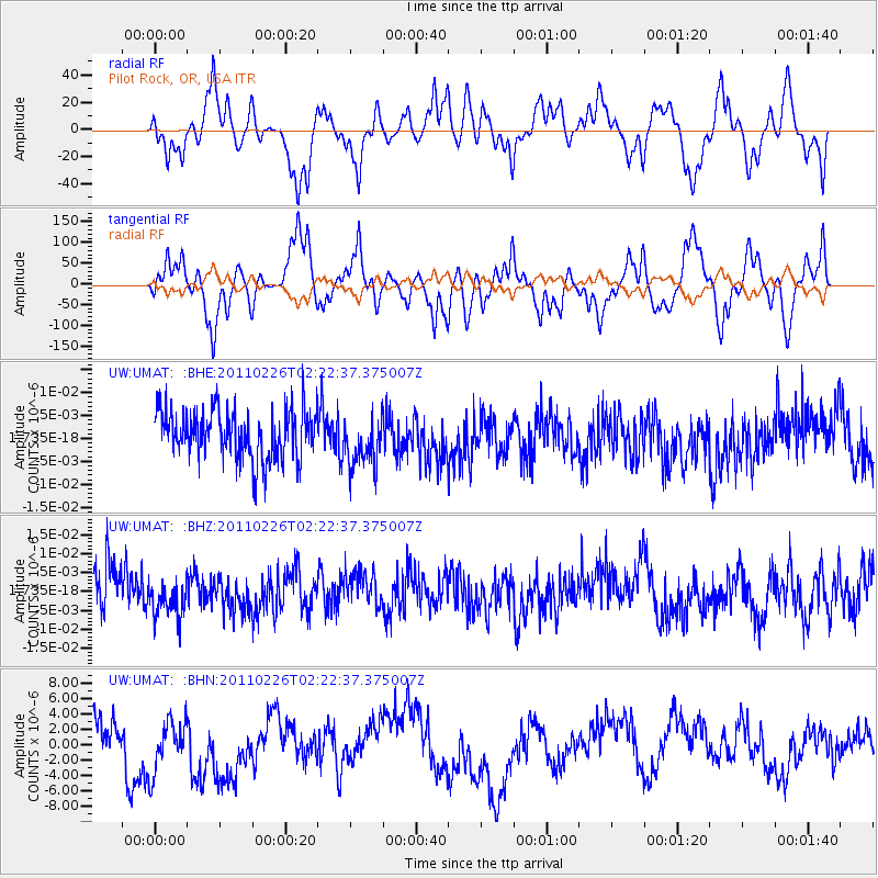
UMAT Pilot Rock, OR, USA - Earthquake Result Viewer
*The percent match for this event was below the threshold and hence no stack was calculated.
| Earthquake location: |
Santa Cruz Islands Region |
| Earthquake latitude/longitude: |
-10.6/164.9 |
| Earthquake time(UTC): |
2011/02/26 (057) 02:10:24 GMT |
| Earthquake Depth: |
49 km |
| Earthquake Magnitude: |
5.6 MB, 5.3 MS, 5.9 MW, 5.9 MW |
| Earthquake Catalog/Contributor: |
WHDF/NEIC |
|
| Network: |
UW Pacific Northwest Regional Seismic Network |
| Station: |
UMAT Pilot Rock, OR, USA |
| Lat/Lon: |
45.29 N/118.96 W |
| Elevation: |
1318 m |
|
| Distance: |
87.9 deg |
| Az: |
43.299 deg |
| Baz: |
252.767 deg |
| Ray Param: |
$rayparam |
*The percent match for this event was below the threshold and hence was not used in the summary stack. |
|
| Radial Match: |
44.417366 % |
| Radial Bump: |
300 |
| Transverse Match: |
44.43263 % |
| Transverse Bump: |
316 |
| SOD ConfigId: |
353373 |
| Insert Time: |
2011-08-01 07:22:26.094 +0000 |
| GWidth: |
2.5 |
| Max Bumps: |
400 |
| Tol: |
0.001 |
|
Signal To Noise
| Channel | StoN | STA | LTA |
| UW:UMAT: :BHZ:20110226T02:22:37.375007Z | 1.1011672 | 5.808672E-9 | 5.2750138E-9 |
| UW:UMAT: :BHN:20110226T02:22:37.375007Z | 1.9145505 | 3.7069885E-6 | 1.9362187E-6 |
| UW:UMAT: :BHE:20110226T02:22:37.375007Z | 1.0680264 | 5.597172E-9 | 5.2406683E-9 |
| Arrivals |
| Ps | |
| PpPs | |
| PsPs/PpSs | |


