You are here: Home > Network List > CI - Caltech Regional Seismic Network Stations List
> Station MPM Manuel Prospect Mine, California, USA > Earthquake Result Viewer
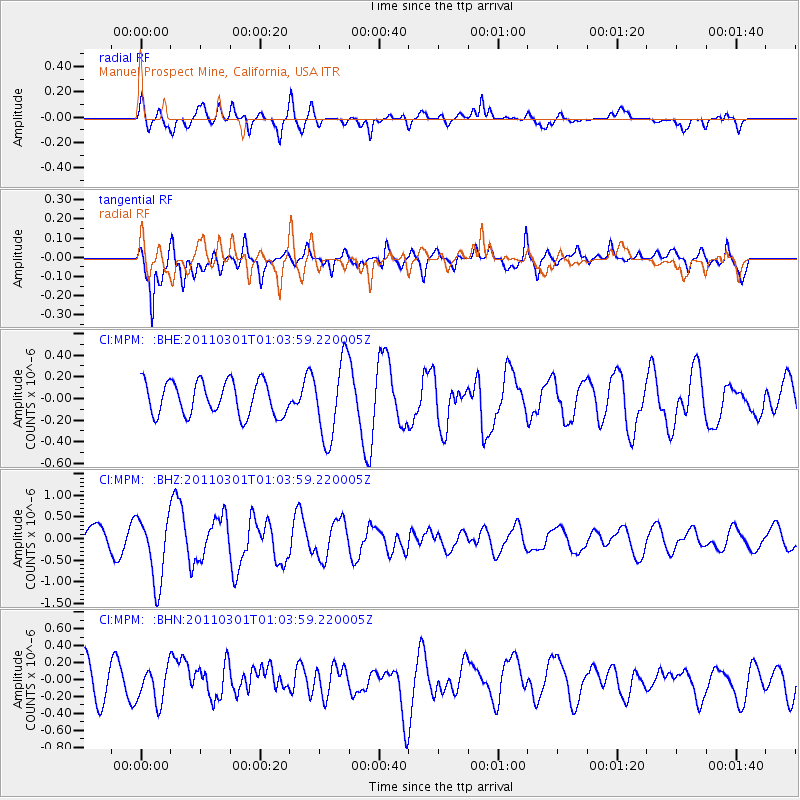
MPM Manuel Prospect Mine, California, USA - Earthquake Result Viewer
*The percent match for this event was below the threshold and hence no stack was calculated.
| Earthquake location: |
Easter Island Region |
| Earthquake latitude/longitude: |
-29.7/-112.0 |
| Earthquake time(UTC): |
2011/03/01 (060) 00:53:46 GMT |
| Earthquake Depth: |
10 km |
| Earthquake Magnitude: |
5.6 MB, 6.0 MS, 6.1 MW, 6.0 MW |
| Earthquake Catalog/Contributor: |
WHDF/NEIC |
|
| Network: |
CI Caltech Regional Seismic Network |
| Station: |
MPM Manuel Prospect Mine, California, USA |
| Lat/Lon: |
36.06 N/117.49 W |
| Elevation: |
185 m |
|
| Distance: |
65.6 deg |
| Az: |
355.101 deg |
| Baz: |
174.739 deg |
| Ray Param: |
$rayparam |
*The percent match for this event was below the threshold and hence was not used in the summary stack. |
|
| Radial Match: |
57.885567 % |
| Radial Bump: |
400 |
| Transverse Match: |
85.665085 % |
| Transverse Bump: |
400 |
| SOD ConfigId: |
353373 |
| Insert Time: |
2011-08-01 07:39:58.635 +0000 |
| GWidth: |
2.5 |
| Max Bumps: |
400 |
| Tol: |
0.001 |
|
Signal To Noise
| Channel | StoN | STA | LTA |
| CI:MPM: :BHZ:20110301T01:03:59.220005Z | 3.1826205 | 7.649506E-7 | 2.4035242E-7 |
| CI:MPM: :BHN:20110301T01:03:59.220005Z | 1.0539534 | 2.036105E-7 | 1.9318738E-7 |
| CI:MPM: :BHE:20110301T01:03:59.220005Z | 2.3233383 | 3.572706E-7 | 1.5377469E-7 |
| Arrivals |
| Ps | |
| PpPs | |
| PsPs/PpSs | |


