You are here: Home > Network List > TA - USArray Transportable Network (new EarthScope stations) Stations List
> Station R30A Dighton, KS, USA > Earthquake Result Viewer
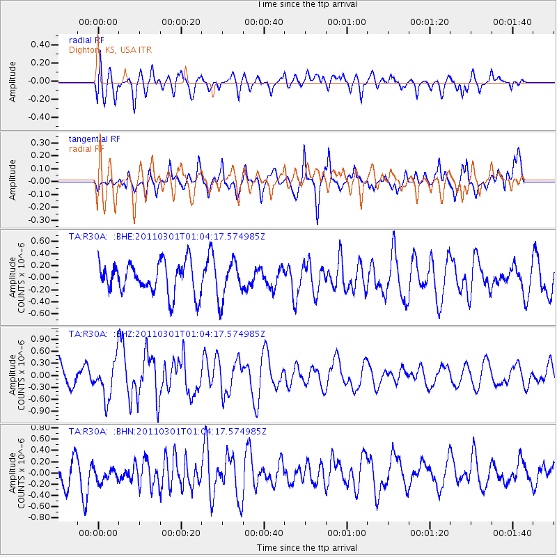
R30A Dighton, KS, USA - Earthquake Result Viewer
*The percent match for this event was below the threshold and hence no stack was calculated.
| Earthquake location: |
Easter Island Region |
| Earthquake latitude/longitude: |
-29.7/-112.0 |
| Earthquake time(UTC): |
2011/03/01 (060) 00:53:46 GMT |
| Earthquake Depth: |
10 km |
| Earthquake Magnitude: |
5.6 MB, 6.0 MS, 6.1 MW, 6.0 MW |
| Earthquake Catalog/Contributor: |
WHDF/NEIC |
|
| Network: |
TA USArray Transportable Network (new EarthScope stations) |
| Station: |
R30A Dighton, KS, USA |
| Lat/Lon: |
38.28 N/100.28 W |
| Elevation: |
776 m |
|
| Distance: |
68.5 deg |
| Az: |
9.879 deg |
| Baz: |
190.934 deg |
| Ray Param: |
$rayparam |
*The percent match for this event was below the threshold and hence was not used in the summary stack. |
|
| Radial Match: |
66.380775 % |
| Radial Bump: |
400 |
| Transverse Match: |
61.29236 % |
| Transverse Bump: |
400 |
| SOD ConfigId: |
353373 |
| Insert Time: |
2011-08-01 07:58:35.371 +0000 |
| GWidth: |
2.5 |
| Max Bumps: |
400 |
| Tol: |
0.001 |
|
Signal To Noise
| Channel | StoN | STA | LTA |
| TA:R30A: :BHZ:20110301T01:04:17.574985Z | 2.3684788 | 4.9700714E-7 | 2.0984236E-7 |
| TA:R30A: :BHN:20110301T01:04:17.574985Z | 0.5259065 | 1.7083232E-7 | 3.2483402E-7 |
| TA:R30A: :BHE:20110301T01:04:17.574985Z | 1.2311839 | 3.1698096E-7 | 2.574603E-7 |
| Arrivals |
| Ps | |
| PpPs | |
| PsPs/PpSs | |


