You are here: Home > Network List > TA - USArray Transportable Network (new EarthScope stations) Stations List
> Station Q30A Quinter, KS, USA > Earthquake Result Viewer
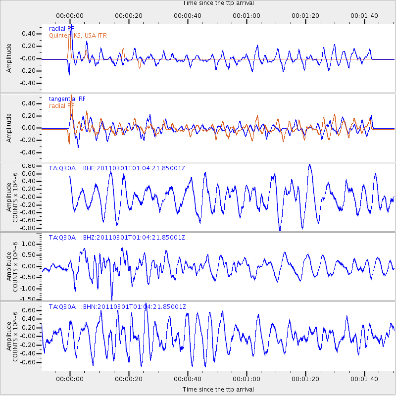
Q30A Quinter, KS, USA - Earthquake Result Viewer
*The percent match for this event was below the threshold and hence no stack was calculated.
| Earthquake location: |
Easter Island Region |
| Earthquake latitude/longitude: |
-29.7/-112.0 |
| Earthquake time(UTC): |
2011/03/01 (060) 00:53:46 GMT |
| Earthquake Depth: |
10 km |
| Earthquake Magnitude: |
5.6 MB, 6.0 MS, 6.1 MW, 6.0 MW |
| Earthquake Catalog/Contributor: |
WHDF/NEIC |
|
| Network: |
TA USArray Transportable Network (new EarthScope stations) |
| Station: |
Q30A Quinter, KS, USA |
| Lat/Lon: |
38.98 N/100.22 W |
| Elevation: |
797 m |
|
| Distance: |
69.2 deg |
| Az: |
9.785 deg |
| Baz: |
190.935 deg |
| Ray Param: |
$rayparam |
*The percent match for this event was below the threshold and hence was not used in the summary stack. |
|
| Radial Match: |
55.274097 % |
| Radial Bump: |
400 |
| Transverse Match: |
67.745445 % |
| Transverse Bump: |
400 |
| SOD ConfigId: |
353373 |
| Insert Time: |
2011-08-01 08:00:03.543 +0000 |
| GWidth: |
2.5 |
| Max Bumps: |
400 |
| Tol: |
0.001 |
|
Signal To Noise
| Channel | StoN | STA | LTA |
| TA:Q30A: :BHZ:20110301T01:04:21.85001Z | 2.620136 | 5.0390275E-7 | 1.923193E-7 |
| TA:Q30A: :BHN:20110301T01:04:21.85001Z | 0.6300822 | 2.3264995E-7 | 3.6923748E-7 |
| TA:Q30A: :BHE:20110301T01:04:21.85001Z | 0.58581036 | 1.8047957E-7 | 3.080853E-7 |
| Arrivals |
| Ps | |
| PpPs | |
| PsPs/PpSs | |


