You are here: Home > Network List > AZ - ANZA Regional Network Stations List
> Station KNW AZ.KNW > Earthquake Result Viewer
KNW AZ.KNW - Earthquake Result Viewer
| Earthquake location: |
Northern Peru |
| Earthquake latitude/longitude: |
-3.9/-77.0 |
| Earthquake time(UTC): |
1995/05/02 (122) 06:06:05 GMT |
| Earthquake Depth: |
103 km |
| Earthquake Magnitude: |
6.5 MB, 6.7 UNKNOWN, 6.6 MW |
| Earthquake Catalog/Contributor: |
WHDF/NEIC |
|
| Network: |
AZ ANZA Regional Network |
| Station: |
KNW AZ.KNW |
| Lat/Lon: |
33.71 N/116.71 W |
| Elevation: |
1507 m |
|
| Distance: |
53.0 deg |
| Az: |
318.097 deg |
| Baz: |
126.921 deg |
| Ray Param: |
0.06609392 |
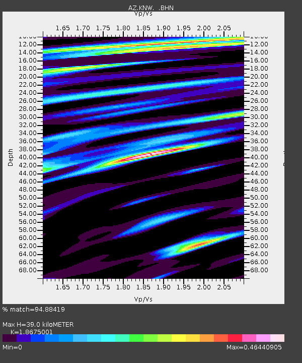
| Estimated Moho Depth: |
39.0 km |
| Estimated Crust Vp/Vs: |
1.87 |
| Assumed Crust Vp: |
6.264 km/s |
| Estimated Crust Vs: |
3.354 km/s |
| Estimated Crust Poisson's Ratio: |
0.30 |
|
| Radial Match: |
94.88419 % |
| Radial Bump: |
347 |
| Transverse Match: |
88.4208 % |
| Transverse Bump: |
400 |
| SOD ConfigId: |
6273 |
| Insert Time: |
2010-02-26 19:31:58.246 +0000 |
| GWidth: |
2.5 |
| Max Bumps: |
400 |
| Tol: |
0.001 |
|
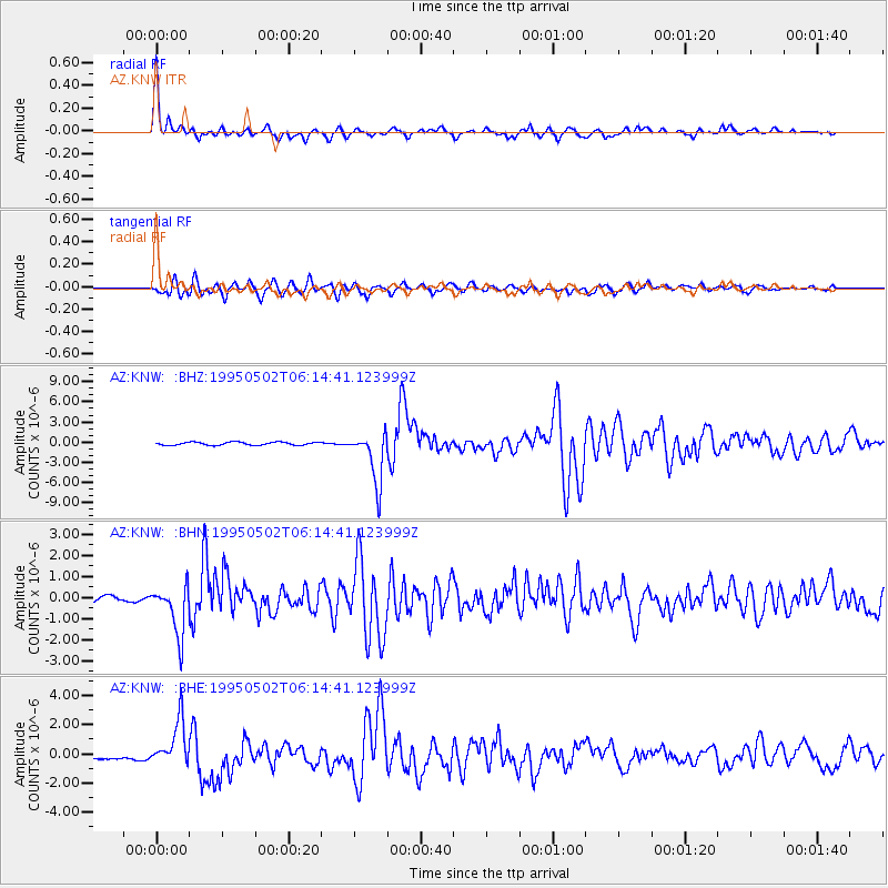
Signal To Noise
| Channel | StoN | STA | LTA |
| AZ:KNW: :BHN:19950502T06:14:41.123999Z | 8.07603 | 1.1901369E-6 | 1.4736658E-7 |
| AZ:KNW: :BHE:19950502T06:14:41.123999Z | 10.917971 | 1.5667086E-6 | 1.4349817E-7 |
| AZ:KNW: :BHZ:19950502T06:14:41.123999Z | 16.185732 | 3.8008425E-6 | 2.3482673E-7 |
| Arrivals |
| Ps | 5.7 SECOND |
| PpPs | 17 SECOND |
| PsPs/PpSs | 23 SECOND |


