You are here: Home > Network List > TA - USArray Transportable Network (new EarthScope stations) Stations List
> Station 434A Burnet, TX, USA > Earthquake Result Viewer
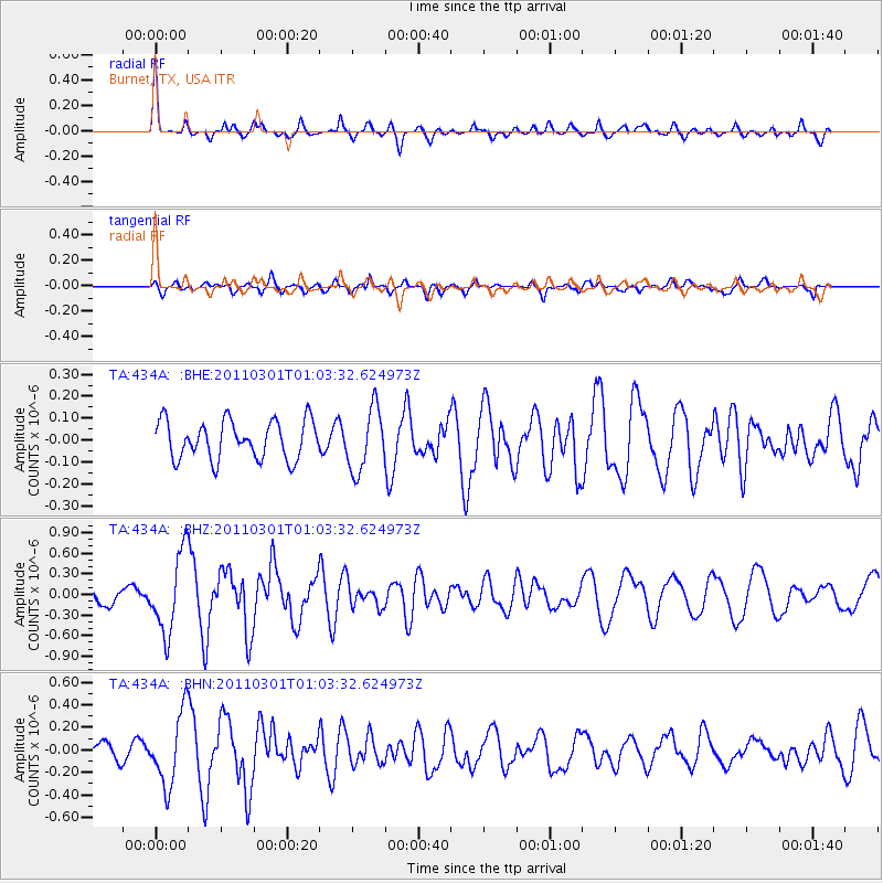
434A Burnet, TX, USA - Earthquake Result Viewer
*The percent match for this event was below the threshold and hence no stack was calculated.
| Earthquake location: |
Easter Island Region |
| Earthquake latitude/longitude: |
-29.7/-112.0 |
| Earthquake time(UTC): |
2011/03/01 (060) 00:53:46 GMT |
| Earthquake Depth: |
10 km |
| Earthquake Magnitude: |
5.6 MB, 6.0 MS, 6.1 MW, 6.0 MW |
| Earthquake Catalog/Contributor: |
WHDF/NEIC |
|
| Network: |
TA USArray Transportable Network (new EarthScope stations) |
| Station: |
434A Burnet, TX, USA |
| Lat/Lon: |
30.81 N/98.27 W |
| Elevation: |
462 m |
|
| Distance: |
61.6 deg |
| Az: |
13.408 deg |
| Baz: |
193.562 deg |
| Ray Param: |
$rayparam |
*The percent match for this event was below the threshold and hence was not used in the summary stack. |
|
| Radial Match: |
74.28401 % |
| Radial Bump: |
313 |
| Transverse Match: |
48.87482 % |
| Transverse Bump: |
346 |
| SOD ConfigId: |
353373 |
| Insert Time: |
2011-08-01 08:15:53.242 +0000 |
| GWidth: |
2.5 |
| Max Bumps: |
400 |
| Tol: |
0.001 |
|
Signal To Noise
| Channel | StoN | STA | LTA |
| TA:434A: :BHZ:20110301T01:03:32.624973Z | 2.7797973 | 5.7403975E-7 | 2.0650417E-7 |
| TA:434A: :BHN:20110301T01:03:32.624973Z | 3.7829237 | 3.1764017E-7 | 8.3966846E-8 |
| TA:434A: :BHE:20110301T01:03:32.624973Z | 1.6471345 | 1.4309289E-7 | 8.687383E-8 |
| Arrivals |
| Ps | |
| PpPs | |
| PsPs/PpSs | |


