You are here: Home > Network List > TA - USArray Transportable Network (new EarthScope stations) Stations List
> Station 334A Lometa, TX, USA > Earthquake Result Viewer
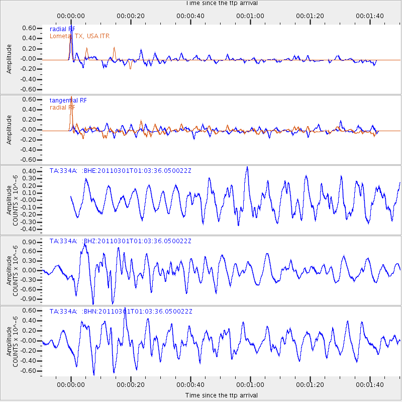
334A Lometa, TX, USA - Earthquake Result Viewer

| Earthquake location: |
Easter Island Region |
| Earthquake latitude/longitude: |
-29.7/-112.0 |
| Earthquake time(UTC): |
2011/03/01 (060) 00:53:46 GMT |
| Earthquake Depth: |
10 km |
| Earthquake Magnitude: |
5.6 MB, 6.0 MS, 6.1 MW, 6.0 MW |
| Earthquake Catalog/Contributor: |
WHDF/NEIC |
|
| Network: |
TA USArray Transportable Network (new EarthScope stations) |
| Station: |
334A Lometa, TX, USA |
| Lat/Lon: |
31.33 N/98.24 W |
| Elevation: |
389 m |
|
| Distance: |
62.1 deg |
| Az: |
13.3 deg |
| Baz: |
193.527 deg |
| Ray Param: |
0.060457617 |
| Estimated Moho Depth: |
55.75 km |
| Estimated Crust Vp/Vs: |
1.88 |
| Assumed Crust Vp: |
6.498 km/s |
| Estimated Crust Vs: |
3.465 km/s |
| Estimated Crust Poisson's Ratio: |
0.30 |
|
| Radial Match: |
85.67467 % |
| Radial Bump: |
377 |
| Transverse Match: |
57.640717 % |
| Transverse Bump: |
325 |
| SOD ConfigId: |
353373 |
| Insert Time: |
2011-08-01 08:18:20.554 +0000 |
| GWidth: |
2.5 |
| Max Bumps: |
400 |
| Tol: |
0.001 |
|
Signal To Noise
| Channel | StoN | STA | LTA |
| TA:334A: :BHZ:20110301T01:03:36.050022Z | 6.107269 | 4.95244E-7 | 8.109091E-8 |
| TA:334A: :BHN:20110301T01:03:36.050022Z | 2.581973 | 2.8496777E-7 | 1.1036822E-7 |
| TA:334A: :BHE:20110301T01:03:36.050022Z | 0.8555414 | 1.1077232E-7 | 1.2947628E-7 |
| Arrivals |
| Ps | 7.8 SECOND |
| PpPs | 24 SECOND |
| PsPs/PpSs | 31 SECOND |


