You are here: Home > Network List > TA - USArray Transportable Network (new EarthScope stations) Stations List
> Station X38A Whitesboro, OK, USA > Earthquake Result Viewer
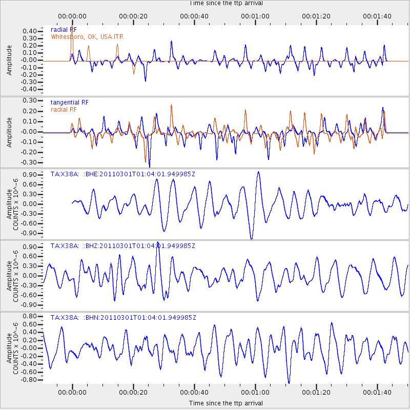
X38A Whitesboro, OK, USA - Earthquake Result Viewer
*The percent match for this event was below the threshold and hence no stack was calculated.
| Earthquake location: |
Easter Island Region |
| Earthquake latitude/longitude: |
-29.7/-112.0 |
| Earthquake time(UTC): |
2011/03/01 (060) 00:53:46 GMT |
| Earthquake Depth: |
10 km |
| Earthquake Magnitude: |
5.6 MB, 6.0 MS, 6.1 MW, 6.0 MW |
| Earthquake Catalog/Contributor: |
WHDF/NEIC |
|
| Network: |
TA USArray Transportable Network (new EarthScope stations) |
| Station: |
X38A Whitesboro, OK, USA |
| Lat/Lon: |
34.67 N/94.83 W |
| Elevation: |
234 m |
|
| Distance: |
66.0 deg |
| Az: |
15.426 deg |
| Baz: |
196.307 deg |
| Ray Param: |
$rayparam |
*The percent match for this event was below the threshold and hence was not used in the summary stack. |
|
| Radial Match: |
51.87373 % |
| Radial Bump: |
294 |
| Transverse Match: |
60.94113 % |
| Transverse Bump: |
297 |
| SOD ConfigId: |
353373 |
| Insert Time: |
2011-08-01 08:40:22.899 +0000 |
| GWidth: |
2.5 |
| Max Bumps: |
400 |
| Tol: |
0.001 |
|
Signal To Noise
| Channel | StoN | STA | LTA |
| TA:X38A: :BHZ:20110301T01:04:01.949985Z | 0.9432167 | 3.2612658E-7 | 3.4576E-7 |
| TA:X38A: :BHN:20110301T01:04:01.949985Z | 0.31982803 | 1.2231557E-7 | 3.824417E-7 |
| TA:X38A: :BHE:20110301T01:04:01.949985Z | 2.818833 | 5.5158586E-7 | 1.956788E-7 |
| Arrivals |
| Ps | |
| PpPs | |
| PsPs/PpSs | |


