You are here: Home > Network List > AZ - ANZA Regional Network Stations List
> Station KNW AZ.KNW > Earthquake Result Viewer
KNW AZ.KNW - Earthquake Result Viewer

| Earthquake location: |
Colombia |
| Earthquake latitude/longitude: |
5.1/-75.7 |
| Earthquake time(UTC): |
1995/08/19 (231) 21:43:32 GMT |
| Earthquake Depth: |
125 km |
| Earthquake Magnitude: |
6.1 MB, 6.6 UNKNOWN, 6.5 MW |
| Earthquake Catalog/Contributor: |
WHDF/NEIC |
|
| Network: |
AZ ANZA Regional Network |
| Station: |
KNW AZ.KNW |
| Lat/Lon: |
33.71 N/116.71 W |
| Elevation: |
1507 m |
|
| Distance: |
47.5 deg |
| Az: |
312.129 deg |
| Baz: |
117.59 deg |
| Ray Param: |
0.06950827 |
| Estimated Moho Depth: |
10.0 km |
| Estimated Crust Vp/Vs: |
2.02 |
| Assumed Crust Vp: |
6.264 km/s |
| Estimated Crust Vs: |
3.097 km/s |
| Estimated Crust Poisson's Ratio: |
0.34 |
|
| Radial Match: |
94.4377 % |
| Radial Bump: |
312 |
| Transverse Match: |
54.702915 % |
| Transverse Bump: |
400 |
| SOD ConfigId: |
6273 |
| Insert Time: |
2010-02-26 19:32:08.310 +0000 |
| GWidth: |
2.5 |
| Max Bumps: |
400 |
| Tol: |
0.001 |
|
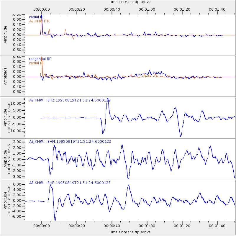
Signal To Noise
| Channel | StoN | STA | LTA |
| AZ:KNW: :BHN:19950819T21:51:24.600012Z | 0.9826177 | 9.227264E-7 | 9.3904924E-7 |
| AZ:KNW: :BHE:19950819T21:51:24.600012Z | 6.173664 | 1.691762E-6 | 2.7402882E-7 |
| AZ:KNW: :BHZ:19950819T21:51:24.600012Z | 24.767855 | 3.1486968E-6 | 1.2712836E-7 |
| Arrivals |
| Ps | 1.7 SECOND |
| PpPs | 4.6 SECOND |
| PsPs/PpSs | 6.3 SECOND |


