You are here: Home > Network List > AZ - ANZA Regional Network Stations List
> Station KNW AZ.KNW > Earthquake Result Viewer
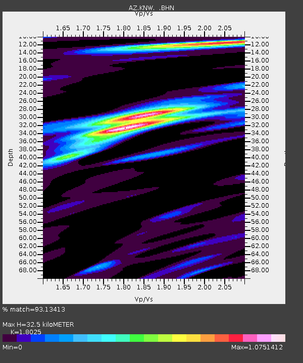
KNW AZ.KNW - Earthquake Result Viewer
| Earthquake location: |
Mariana Islands |
| Earthquake latitude/longitude: |
18.9/145.2 |
| Earthquake time(UTC): |
1995/08/23 (235) 07:06:02 GMT |
| Earthquake Depth: |
596 km |
| Earthquake Magnitude: |
6.3 MB, 6.3 UNKNOWN, 7.0 MW |
| Earthquake Catalog/Contributor: |
WHDF/NEIC |
|
| Network: |
AZ ANZA Regional Network |
| Station: |
KNW AZ.KNW |
| Lat/Lon: |
33.71 N/116.71 W |
| Elevation: |
1507 m |
|
| Distance: |
86.2 deg |
| Az: |
55.795 deg |
| Baz: |
290.016 deg |
| Ray Param: |
0.042490322 |
| Estimated Moho Depth: |
32.5 km |
| Estimated Crust Vp/Vs: |
1.80 |
| Assumed Crust Vp: |
6.264 km/s |
| Estimated Crust Vs: |
3.475 km/s |
| Estimated Crust Poisson's Ratio: |
0.28 |
|
| Radial Match: |
93.13413 % |
| Radial Bump: |
400 |
| Transverse Match: |
92.684135 % |
| Transverse Bump: |
400 |
| SOD ConfigId: |
6273 |
| Insert Time: |
2010-02-26 19:32:13.766 +0000 |
| GWidth: |
2.5 |
| Max Bumps: |
400 |
| Tol: |
0.001 |
|

Signal To Noise
| Channel | StoN | STA | LTA |
| AZ:KNW: :BHN:19950823T07:17:10.600Z | 7.1191463 | 4.4512254E-7 | 6.252471E-8 |
| AZ:KNW: :BHE:19950823T07:17:10.600Z | 12.524741 | 6.9945196E-7 | 5.584562E-8 |
| AZ:KNW: :BHZ:19950823T07:17:10.600Z | 34.10687 | 2.7817744E-6 | 8.1560536E-8 |
| Arrivals |
| Ps | 4.2 SECOND |
| PpPs | 14 SECOND |
| PsPs/PpSs | 19 SECOND |


