You are here: Home > Network List > AR - Northern Arizona Network Stations List
> Station W13A Hualapai Mountain Park, Kingman, AZ, USA > Earthquake Result Viewer
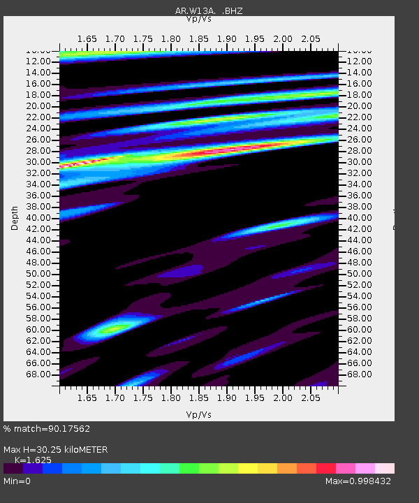
W13A Hualapai Mountain Park, Kingman, AZ, USA - Earthquake Result Viewer
| Earthquake location: |
Northern Chile |
| Earthquake latitude/longitude: |
-18.0/-69.4 |
| Earthquake time(UTC): |
2011/03/06 (065) 12:31:59 GMT |
| Earthquake Depth: |
118 km |
| Earthquake Magnitude: |
6.0 MB, 6.3 MW, 6.3 MW |
| Earthquake Catalog/Contributor: |
WHDF/NEIC |
|
| Network: |
AR Northern Arizona Network |
| Station: |
W13A Hualapai Mountain Park, Kingman, AZ, USA |
| Lat/Lon: |
35.10 N/113.89 W |
| Elevation: |
1988 m |
|
| Distance: |
67.6 deg |
| Az: |
321.562 deg |
| Baz: |
133.828 deg |
| Ray Param: |
0.056508027 |
| Estimated Moho Depth: |
30.25 km |
| Estimated Crust Vp/Vs: |
1.62 |
| Assumed Crust Vp: |
6.276 km/s |
| Estimated Crust Vs: |
3.862 km/s |
| Estimated Crust Poisson's Ratio: |
0.20 |
|
| Radial Match: |
90.17562 % |
| Radial Bump: |
400 |
| Transverse Match: |
53.2291 % |
| Transverse Bump: |
400 |
| SOD ConfigId: |
354511 |
| Insert Time: |
2011-08-09 06:37:32.650 +0000 |
| GWidth: |
2.5 |
| Max Bumps: |
400 |
| Tol: |
0.001 |
|

Signal To Noise
| Channel | StoN | STA | LTA |
| AR:W13A: :BHZ:20110306T12:42:13.249971Z | 6.820772 | 8.01886E-7 | 1.17565286E-7 |
| AR:W13A: :BHN:20110306T12:42:13.249971Z | 1.7115415 | 1.8694583E-7 | 1.09226576E-7 |
| AR:W13A: :BHE:20110306T12:42:13.249971Z | 1.670402 | 1.8110768E-7 | 1.0842161E-7 |
| Arrivals |
| Ps | 3.1 SECOND |
| PpPs | 12 SECOND |
| PsPs/PpSs | 15 SECOND |


