You are here: Home > Network List > XL12 - Hangay Dome, Mongolia Stations List
> Station HD47 HD47 > Earthquake Result Viewer
HD47 HD47 - Earthquake Result Viewer
| Earthquake location: |
Java, Indonesia |
| Earthquake latitude/longitude: |
-8.0/109.3 |
| Earthquake time(UTC): |
2014/01/25 (025) 05:14:18 GMT |
| Earthquake Depth: |
66 km |
| Earthquake Magnitude: |
6.1 MWW, 6.1 MWC, 6.2 MWC, 6.2 MWB |
| Earthquake Catalog/Contributor: |
NEIC PDE/NEIC COMCAT |
|
| Network: |
XL Hangay Dome, Mongolia |
| Station: |
HD47 HD47 |
| Lat/Lon: |
46.15 N/100.14 E |
| Elevation: |
1985 m |
|
| Distance: |
54.5 deg |
| Az: |
352.22 deg |
| Baz: |
168.881 deg |
| Ray Param: |
0.06523295 |
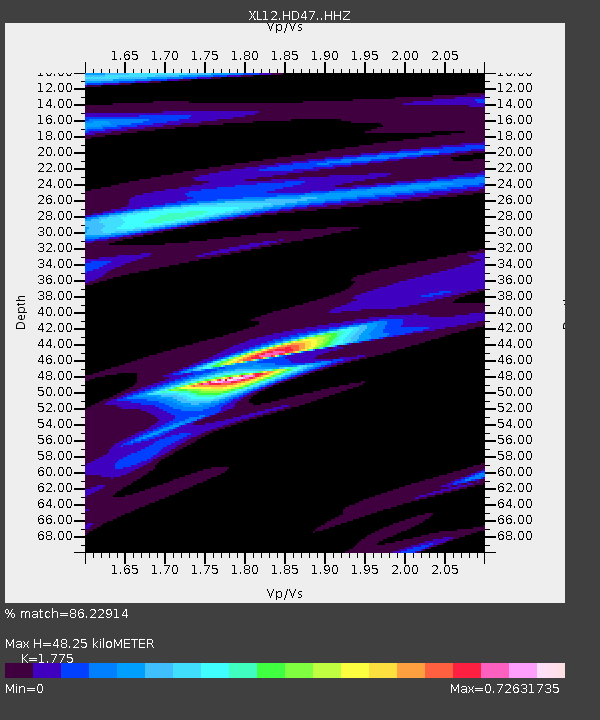
| Estimated Moho Depth: |
48.25 km |
| Estimated Crust Vp/Vs: |
1.77 |
| Assumed Crust Vp: |
6.642 km/s |
| Estimated Crust Vs: |
3.742 km/s |
| Estimated Crust Poisson's Ratio: |
0.27 |
|
| Radial Match: |
86.22914 % |
| Radial Bump: |
316 |
| Transverse Match: |
77.89625 % |
| Transverse Bump: |
400 |
| SOD ConfigId: |
3390531 |
| Insert Time: |
2019-04-10 02:38:10.849 +0000 |
| GWidth: |
2.5 |
| Max Bumps: |
400 |
| Tol: |
0.001 |
|

Signal To Noise
| Channel | StoN | STA | LTA |
| XL:HD47: :HHZ:20140125T05:23:08.98998Z | 18.540405 | 1.3159733E-6 | 7.097867E-8 |
| XL:HD47: :HHN:20140125T05:23:08.98998Z | 4.818001 | 6.3440706E-7 | 1.3167433E-7 |
| XL:HD47: :HHE:20140125T05:23:08.98998Z | 1.770805 | 1.5055741E-7 | 8.502202E-8 |
| Arrivals |
| Ps | 6.0 SECOND |
| PpPs | 19 SECOND |
| PsPs/PpSs | 25 SECOND |


