You are here: Home > Network List > XL12 - Hangay Dome, Mongolia Stations List
> Station HD51 HD51 > Earthquake Result Viewer
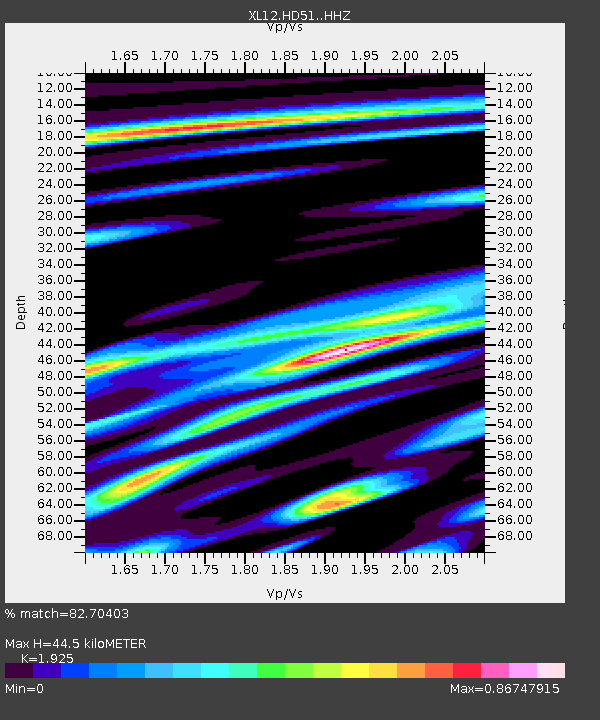
HD51 HD51 - Earthquake Result Viewer
| Earthquake location: |
Java, Indonesia |
| Earthquake latitude/longitude: |
-8.0/109.3 |
| Earthquake time(UTC): |
2014/01/25 (025) 05:14:18 GMT |
| Earthquake Depth: |
66 km |
| Earthquake Magnitude: |
6.1 MWW, 6.1 MWC, 6.2 MWC, 6.2 MWB |
| Earthquake Catalog/Contributor: |
NEIC PDE/NEIC COMCAT |
|
| Network: |
XL Hangay Dome, Mongolia |
| Station: |
HD51 HD51 |
| Lat/Lon: |
46.80 N/97.19 E |
| Elevation: |
2174 m |
|
| Distance: |
55.6 deg |
| Az: |
349.965 deg |
| Baz: |
165.452 deg |
| Ray Param: |
0.064517446 |
| Estimated Moho Depth: |
44.5 km |
| Estimated Crust Vp/Vs: |
1.92 |
| Assumed Crust Vp: |
6.642 km/s |
| Estimated Crust Vs: |
3.45 km/s |
| Estimated Crust Poisson's Ratio: |
0.32 |
|
| Radial Match: |
82.70403 % |
| Radial Bump: |
400 |
| Transverse Match: |
98.11667 % |
| Transverse Bump: |
133 |
| SOD ConfigId: |
3390531 |
| Insert Time: |
2019-04-10 02:38:12.720 +0000 |
| GWidth: |
2.5 |
| Max Bumps: |
400 |
| Tol: |
0.001 |
|

Signal To Noise
| Channel | StoN | STA | LTA |
| XL:HD51: :HHZ:20140125T05:23:16.790029Z | 12.495687 | 6.901942E-7 | 5.5234597E-8 |
| XL:HD51: :HHN:20140125T05:23:16.790029Z | 2.4186947 | 2.8760712E-7 | 1.1891005E-7 |
| XL:HD51: :HHE:20140125T05:23:16.790029Z | 7.7964654 | 6.853661E-7 | 8.790729E-8 |
| Arrivals |
| Ps | 6.5 SECOND |
| PpPs | 19 SECOND |
| PsPs/PpSs | 25 SECOND |


