You are here: Home > Network List > G - GEOSCOPE Stations List
> Station TAM Tamanrasset, Algeria > Earthquake Result Viewer
TAM Tamanrasset, Algeria - Earthquake Result Viewer
| Earthquake location: |
Northern Chile |
| Earthquake latitude/longitude: |
-18.0/-69.4 |
| Earthquake time(UTC): |
2011/03/06 (065) 12:31:59 GMT |
| Earthquake Depth: |
118 km |
| Earthquake Magnitude: |
6.0 MB, 6.3 MW, 6.3 MW |
| Earthquake Catalog/Contributor: |
WHDF/NEIC |
|
| Network: |
G GEOSCOPE |
| Station: |
TAM Tamanrasset, Algeria |
| Lat/Lon: |
22.79 N/5.53 E |
| Elevation: |
1377 m |
|
| Distance: |
83.7 deg |
| Az: |
63.692 deg |
| Baz: |
247.564 deg |
| Ray Param: |
0.04576898 |
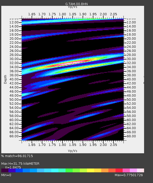
| Estimated Moho Depth: |
31.75 km |
| Estimated Crust Vp/Vs: |
1.85 |
| Assumed Crust Vp: |
6.61 km/s |
| Estimated Crust Vs: |
3.578 km/s |
| Estimated Crust Poisson's Ratio: |
0.29 |
|
| Radial Match: |
96.81715 % |
| Radial Bump: |
255 |
| Transverse Match: |
90.095436 % |
| Transverse Bump: |
396 |
| SOD ConfigId: |
354511 |
| Insert Time: |
2011-08-09 06:56:00.125 +0000 |
| GWidth: |
2.5 |
| Max Bumps: |
400 |
| Tol: |
0.001 |
|
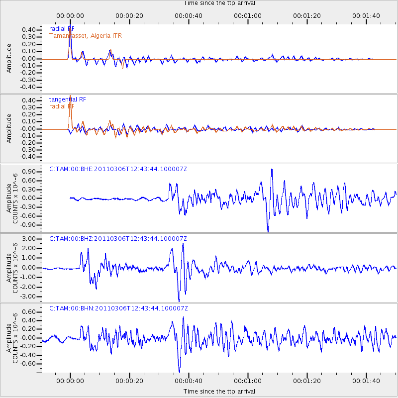
Signal To Noise
| Channel | StoN | STA | LTA |
| G:TAM:00:BHZ:20110306T12:43:44.100007Z | 9.215055 | 5.505222E-7 | 5.974161E-8 |
| G:TAM:00:BHN:20110306T12:43:44.100007Z | 2.599442 | 1.0432664E-7 | 4.0134243E-8 |
| G:TAM:00:BHE:20110306T12:43:44.100007Z | 7.472657 | 1.791221E-7 | 2.3970335E-8 |
| Arrivals |
| Ps | 4.2 SECOND |
| PpPs | 13 SECOND |
| PsPs/PpSs | 18 SECOND |


