You are here: Home > Network List > YB13 - Continental Dynamics/Cent. Anatolian Tectonics:Surface to Mantle Dynamics During Stations List
> Station AT05 Ormanici,Malatya,Turkey > Earthquake Result Viewer
AT05 Ormanici,Malatya,Turkey - Earthquake Result Viewer
| Earthquake location: |
Java, Indonesia |
| Earthquake latitude/longitude: |
-8.0/109.3 |
| Earthquake time(UTC): |
2014/01/25 (025) 05:14:18 GMT |
| Earthquake Depth: |
66 km |
| Earthquake Magnitude: |
6.1 MWW, 6.1 MWC, 6.2 MWC, 6.2 MWB |
| Earthquake Catalog/Contributor: |
NEIC PDE/NEIC COMCAT |
|
| Network: |
YB Continental Dynamics/Cent. Anatolian Tectonics:Surface to Mantle Dynamics During |
| Station: |
AT05 Ormanici,Malatya,Turkey |
| Lat/Lon: |
38.22 N/38.79 E |
| Elevation: |
851 m |
|
| Distance: |
79.9 deg |
| Az: |
311.052 deg |
| Baz: |
108.519 deg |
| Ray Param: |
0.048528533 |
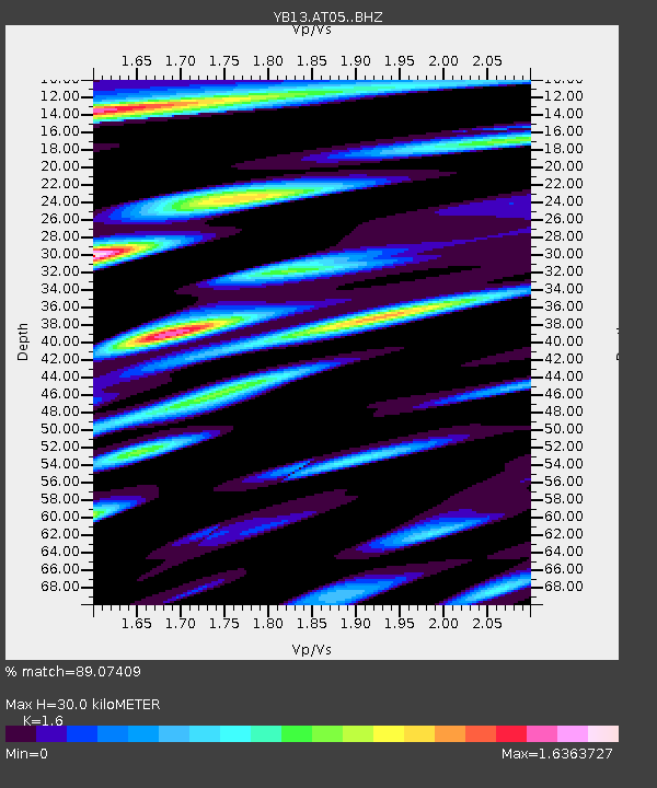
| Estimated Moho Depth: |
30.0 km |
| Estimated Crust Vp/Vs: |
1.60 |
| Assumed Crust Vp: |
6.35 km/s |
| Estimated Crust Vs: |
3.969 km/s |
| Estimated Crust Poisson's Ratio: |
0.18 |
|
| Radial Match: |
89.07409 % |
| Radial Bump: |
400 |
| Transverse Match: |
82.50728 % |
| Transverse Bump: |
400 |
| SOD ConfigId: |
3390531 |
| Insert Time: |
2019-04-10 02:38:57.585 +0000 |
| GWidth: |
2.5 |
| Max Bumps: |
400 |
| Tol: |
0.001 |
|

Signal To Noise
| Channel | StoN | STA | LTA |
| YB:AT05: :BHZ:20140125T05:25:48.580007Z | 29.03151 | 2.3019443E-6 | 7.929124E-8 |
| YB:AT05: :BHN:20140125T05:25:48.580007Z | 3.9271505 | 3.4501235E-7 | 8.78531E-8 |
| YB:AT05: :BHE:20140125T05:25:48.580007Z | 11.024656 | 7.491743E-7 | 6.795444E-8 |
| Arrivals |
| Ps | 2.9 SECOND |
| PpPs | 12 SECOND |
| PsPs/PpSs | 15 SECOND |


