You are here: Home > Network List > YB13 - Continental Dynamics/Cent. Anatolian Tectonics:Surface to Mantle Dynamics During Stations List
> Station AT12 Hamzali,Yozgat,Turkey > Earthquake Result Viewer
AT12 Hamzali,Yozgat,Turkey - Earthquake Result Viewer
| Earthquake location: |
Java, Indonesia |
| Earthquake latitude/longitude: |
-8.0/109.3 |
| Earthquake time(UTC): |
2014/01/25 (025) 05:14:18 GMT |
| Earthquake Depth: |
66 km |
| Earthquake Magnitude: |
6.1 MWW, 6.1 MWC, 6.2 MWC, 6.2 MWB |
| Earthquake Catalog/Contributor: |
NEIC PDE/NEIC COMCAT |
|
| Network: |
YB Continental Dynamics/Cent. Anatolian Tectonics:Surface to Mantle Dynamics During |
| Station: |
AT12 Hamzali,Yozgat,Turkey |
| Lat/Lon: |
39.45 N/34.75 E |
| Elevation: |
1007 m |
|
| Distance: |
83.3 deg |
| Az: |
311.293 deg |
| Baz: |
106.025 deg |
| Ray Param: |
0.04618421 |
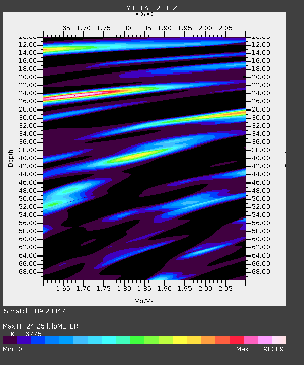
| Estimated Moho Depth: |
24.25 km |
| Estimated Crust Vp/Vs: |
1.68 |
| Assumed Crust Vp: |
6.35 km/s |
| Estimated Crust Vs: |
3.785 km/s |
| Estimated Crust Poisson's Ratio: |
0.22 |
|
| Radial Match: |
89.23347 % |
| Radial Bump: |
400 |
| Transverse Match: |
78.57808 % |
| Transverse Bump: |
400 |
| SOD ConfigId: |
3390531 |
| Insert Time: |
2019-04-10 02:39:02.363 +0000 |
| GWidth: |
2.5 |
| Max Bumps: |
400 |
| Tol: |
0.001 |
|

Signal To Noise
| Channel | StoN | STA | LTA |
| YB:AT12: :BHZ:20140125T05:26:06.340017Z | 30.69053 | 4.301958E-6 | 1.4017216E-7 |
| YB:AT12: :BHN:20140125T05:26:06.340017Z | 5.1545186 | 5.4041584E-7 | 1.0484313E-7 |
| YB:AT12: :BHE:20140125T05:26:06.340017Z | 16.248524 | 1.0208604E-6 | 6.282788E-8 |
| Arrivals |
| Ps | 2.7 SECOND |
| PpPs | 10.0 SECOND |
| PsPs/PpSs | 13 SECOND |


