You are here: Home > Network List > AZ - ANZA Regional Network Stations List
> Station KNW AZ.KNW > Earthquake Result Viewer
KNW AZ.KNW - Earthquake Result Viewer

| Earthquake location: |
Northern Peru |
| Earthquake latitude/longitude: |
-4.4/-76.7 |
| Earthquake time(UTC): |
1997/10/28 (301) 06:15:17 GMT |
| Earthquake Depth: |
112 km |
| Earthquake Magnitude: |
6.6 MB, 6.3 MS, 7.2 UNKNOWN, 6.6 ME |
| Earthquake Catalog/Contributor: |
WHDF/NEIC |
|
| Network: |
AZ ANZA Regional Network |
| Station: |
KNW AZ.KNW |
| Lat/Lon: |
33.71 N/116.71 W |
| Elevation: |
1507 m |
|
| Distance: |
53.5 deg |
| Az: |
318.178 deg |
| Baz: |
127.09 deg |
| Ray Param: |
0.065683916 |
| Estimated Moho Depth: |
38.0 km |
| Estimated Crust Vp/Vs: |
1.92 |
| Assumed Crust Vp: |
6.264 km/s |
| Estimated Crust Vs: |
3.267 km/s |
| Estimated Crust Poisson's Ratio: |
0.31 |
|
| Radial Match: |
96.504555 % |
| Radial Bump: |
315 |
| Transverse Match: |
90.09312 % |
| Transverse Bump: |
400 |
| SOD ConfigId: |
9875 |
| Insert Time: |
2010-02-26 19:32:50.584 +0000 |
| GWidth: |
2.5 |
| Max Bumps: |
400 |
| Tol: |
0.001 |
|
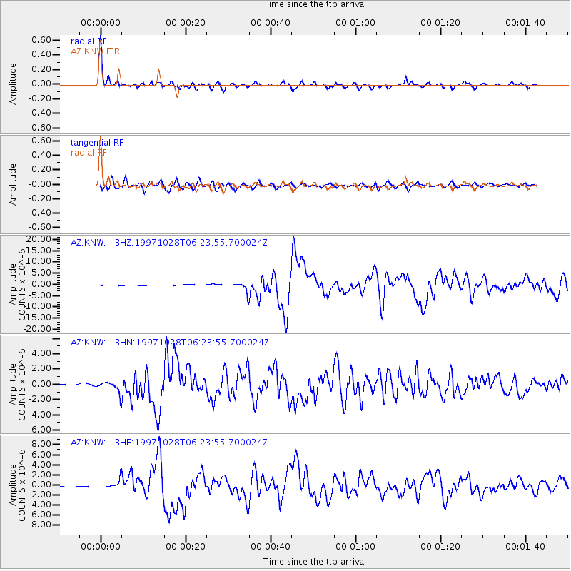
Signal To Noise
| Channel | StoN | STA | LTA |
| AZ:KNW: :BHN:19971028T06:23:55.700024Z | 5.197906 | 7.320466E-7 | 1.4083491E-7 |
| AZ:KNW: :BHE:19971028T06:23:55.700024Z | 8.0731535 | 9.0452977E-7 | 1.1204169E-7 |
| AZ:KNW: :BHZ:19971028T06:23:55.700024Z | 12.554082 | 2.135438E-6 | 1.700991E-7 |
| Arrivals |
| Ps | 5.8 SECOND |
| PpPs | 17 SECOND |
| PsPs/PpSs | 23 SECOND |


