You are here: Home > Network List > AZ - ANZA Regional Network Stations List
> Station KNW AZ.KNW > Earthquake Result Viewer
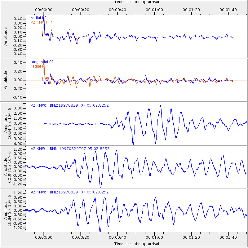
KNW AZ.KNW - Earthquake Result Viewer

| Earthquake location: |
Tonga Islands |
| Earthquake latitude/longitude: |
-15.2/-175.6 |
| Earthquake time(UTC): |
1997/08/29 (241) 06:54:00 GMT |
| Earthquake Depth: |
33 km |
| Earthquake Magnitude: |
5.6 MB, 6.4 MS, 6.5 UNKNOWN, 6.4 MW |
| Earthquake Catalog/Contributor: |
WHDF/NEIC |
|
| Network: |
AZ ANZA Regional Network |
| Station: |
KNW AZ.KNW |
| Lat/Lon: |
33.71 N/116.71 W |
| Elevation: |
1507 m |
|
| Distance: |
74.2 deg |
| Az: |
47.847 deg |
| Baz: |
239.155 deg |
| Ray Param: |
0.052424844 |
| Estimated Moho Depth: |
29.0 km |
| Estimated Crust Vp/Vs: |
1.95 |
| Assumed Crust Vp: |
6.264 km/s |
| Estimated Crust Vs: |
3.208 km/s |
| Estimated Crust Poisson's Ratio: |
0.32 |
|
| Radial Match: |
93.36 % |
| Radial Bump: |
400 |
| Transverse Match: |
86.3589 % |
| Transverse Bump: |
400 |
| SOD ConfigId: |
9875 |
| Insert Time: |
2010-02-26 19:33:01.654 +0000 |
| GWidth: |
2.5 |
| Max Bumps: |
400 |
| Tol: |
0.001 |
|
Signal To Noise
| Channel | StoN | STA | LTA |
| AZ:KNW: :BHN:19970829T07:05:02.825Z | 0.5908397 | 5.528087E-8 | 9.356324E-8 |
| AZ:KNW: :BHE:19970829T07:05:02.825Z | 0.9716241 | 9.370267E-8 | 9.643922E-8 |
| AZ:KNW: :BHZ:19970829T07:05:02.825Z | 1.1049453 | 9.159524E-8 | 8.2895724E-8 |
| Arrivals |
| Ps | 4.5 SECOND |
| PpPs | 13 SECOND |
| PsPs/PpSs | 18 SECOND |


