You are here: Home > Network List > TA - USArray Transportable Network (new EarthScope stations) Stations List
> Station H25A Fruitdale, SD, USA > Earthquake Result Viewer
H25A Fruitdale, SD, USA - Earthquake Result Viewer
| Earthquake location: |
Northern Chile |
| Earthquake latitude/longitude: |
-18.0/-69.4 |
| Earthquake time(UTC): |
2011/03/06 (065) 12:31:59 GMT |
| Earthquake Depth: |
118 km |
| Earthquake Magnitude: |
6.0 MB, 6.3 MW, 6.3 MW |
| Earthquake Catalog/Contributor: |
WHDF/NEIC |
|
| Network: |
TA USArray Transportable Network (new EarthScope stations) |
| Station: |
H25A Fruitdale, SD, USA |
| Lat/Lon: |
44.62 N/103.60 W |
| Elevation: |
942 m |
|
| Distance: |
69.7 deg |
| Az: |
334.64 deg |
| Baz: |
145.2 deg |
| Ray Param: |
0.055149004 |
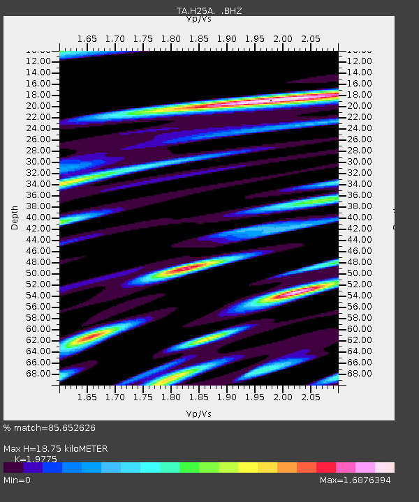
| Estimated Moho Depth: |
18.75 km |
| Estimated Crust Vp/Vs: |
1.98 |
| Assumed Crust Vp: |
6.242 km/s |
| Estimated Crust Vs: |
3.157 km/s |
| Estimated Crust Poisson's Ratio: |
0.33 |
|
| Radial Match: |
85.652626 % |
| Radial Bump: |
400 |
| Transverse Match: |
80.69363 % |
| Transverse Bump: |
400 |
| SOD ConfigId: |
354511 |
| Insert Time: |
2011-08-09 07:23:55.541 +0000 |
| GWidth: |
2.5 |
| Max Bumps: |
400 |
| Tol: |
0.001 |
|
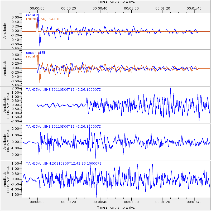
Signal To Noise
| Channel | StoN | STA | LTA |
| TA:H25A: :BHZ:20110306T12:42:26.100007Z | 7.6492662 | 7.4153536E-7 | 9.6942024E-8 |
| TA:H25A: :BHN:20110306T12:42:26.100007Z | 2.2040725 | 4.5304068E-7 | 2.0554708E-7 |
| TA:H25A: :BHE:20110306T12:42:26.100007Z | 3.835302 | 4.511335E-7 | 1.1762659E-7 |
| Arrivals |
| Ps | 3.0 SECOND |
| PpPs | 8.7 SECOND |
| PsPs/PpSs | 12 SECOND |


