You are here: Home > Network List > ZJ12 - Transantarctic Mountains Northern Network Stations List
> Station RAPH Exposure Hill, Antarctica > Earthquake Result Viewer
RAPH Exposure Hill, Antarctica - Earthquake Result Viewer
| Earthquake location: |
Java, Indonesia |
| Earthquake latitude/longitude: |
-8.0/109.3 |
| Earthquake time(UTC): |
2014/01/25 (025) 05:14:18 GMT |
| Earthquake Depth: |
66 km |
| Earthquake Magnitude: |
6.1 MWW, 6.1 MWC, 6.2 MWC, 6.2 MWB |
| Earthquake Catalog/Contributor: |
NEIC PDE/NEIC COMCAT |
|
| Network: |
ZJ Transantarctic Mountains Northern Network |
| Station: |
RAPH Exposure Hill, Antarctica |
| Lat/Lon: |
73.60 S/162.29 E |
| Elevation: |
3052 m |
|
| Distance: |
72.4 deg |
| Az: |
166.227 deg |
| Baz: |
303.914 deg |
| Ray Param: |
0.053513177 |
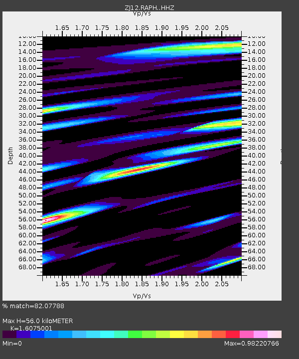
| Estimated Moho Depth: |
56.0 km |
| Estimated Crust Vp/Vs: |
1.61 |
| Assumed Crust Vp: |
6.264 km/s |
| Estimated Crust Vs: |
3.897 km/s |
| Estimated Crust Poisson's Ratio: |
0.18 |
|
| Radial Match: |
82.07788 % |
| Radial Bump: |
400 |
| Transverse Match: |
65.71296 % |
| Transverse Bump: |
400 |
| SOD ConfigId: |
3390531 |
| Insert Time: |
2019-04-10 02:40:09.549 +0000 |
| GWidth: |
2.5 |
| Max Bumps: |
400 |
| Tol: |
0.001 |
|

Signal To Noise
| Channel | StoN | STA | LTA |
| ZJ:RAPH: :HHZ:20140125T05:25:06.288992Z | 6.9506693 | 7.701297E-7 | 1.1079936E-7 |
| ZJ:RAPH: :HHN:20140125T05:25:06.288992Z | 3.197009 | 2.7678158E-7 | 8.657516E-8 |
| ZJ:RAPH: :HHE:20140125T05:25:06.288992Z | 2.9808445 | 3.8089138E-7 | 1.2777969E-7 |
| Arrivals |
| Ps | 5.6 SECOND |
| PpPs | 22 SECOND |
| PsPs/PpSs | 28 SECOND |


