You are here: Home > Network List > TA - USArray Transportable Network (new EarthScope stations) Stations List
> Station R11A Troy Canyon, Currant, NV, USA > Earthquake Result Viewer
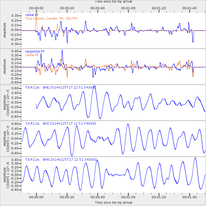
R11A Troy Canyon, Currant, NV, USA - Earthquake Result Viewer
*The percent match for this event was below the threshold and hence no stack was calculated.
| Earthquake location: |
Solomon Islands |
| Earthquake latitude/longitude: |
-7.9/156.0 |
| Earthquake time(UTC): |
2014/01/25 (025) 17:00:10 GMT |
| Earthquake Depth: |
36 km |
| Earthquake Magnitude: |
5.3 MW |
| Earthquake Catalog/Contributor: |
ISC/ISC |
|
| Network: |
TA USArray Transportable Network (new EarthScope stations) |
| Station: |
R11A Troy Canyon, Currant, NV, USA |
| Lat/Lon: |
38.35 N/115.59 W |
| Elevation: |
1756 m |
|
| Distance: |
93.6 deg |
| Az: |
51.958 deg |
| Baz: |
262.883 deg |
| Ray Param: |
$rayparam |
*The percent match for this event was below the threshold and hence was not used in the summary stack. |
|
| Radial Match: |
59.72537 % |
| Radial Bump: |
341 |
| Transverse Match: |
76.90878 % |
| Transverse Bump: |
400 |
| SOD ConfigId: |
3390531 |
| Insert Time: |
2019-04-10 02:43:02.491 +0000 |
| GWidth: |
2.5 |
| Max Bumps: |
400 |
| Tol: |
0.001 |
|
Signal To Noise
| Channel | StoN | STA | LTA |
| TA:R11A: :BHZ:20140125T17:12:51.54999Z | 0.79475266 | 1.9408151E-7 | 2.4420365E-7 |
| TA:R11A: :BHN:20140125T17:12:51.54999Z | 1.373165 | 1.5666613E-7 | 1.14091264E-7 |
| TA:R11A: :BHE:20140125T17:12:51.54999Z | 2.4576013 | 4.3764643E-7 | 1.780787E-7 |
| Arrivals |
| Ps | |
| PpPs | |
| PsPs/PpSs | |


