You are here: Home > Network List > TA - USArray Transportable Network (new EarthScope stations) Stations List
> Station S36A Lake Cedric, Chanute, KS, USA > Earthquake Result Viewer
S36A Lake Cedric, Chanute, KS, USA - Earthquake Result Viewer
| Earthquake location: |
Northern Chile |
| Earthquake latitude/longitude: |
-18.0/-69.4 |
| Earthquake time(UTC): |
2011/03/06 (065) 12:31:59 GMT |
| Earthquake Depth: |
118 km |
| Earthquake Magnitude: |
6.0 MB, 6.3 MW, 6.3 MW |
| Earthquake Catalog/Contributor: |
WHDF/NEIC |
|
| Network: |
TA USArray Transportable Network (new EarthScope stations) |
| Station: |
S36A Lake Cedric, Chanute, KS, USA |
| Lat/Lon: |
37.72 N/95.59 W |
| Elevation: |
299 m |
|
| Distance: |
60.7 deg |
| Az: |
336.302 deg |
| Baz: |
151.165 deg |
| Ray Param: |
0.061016116 |
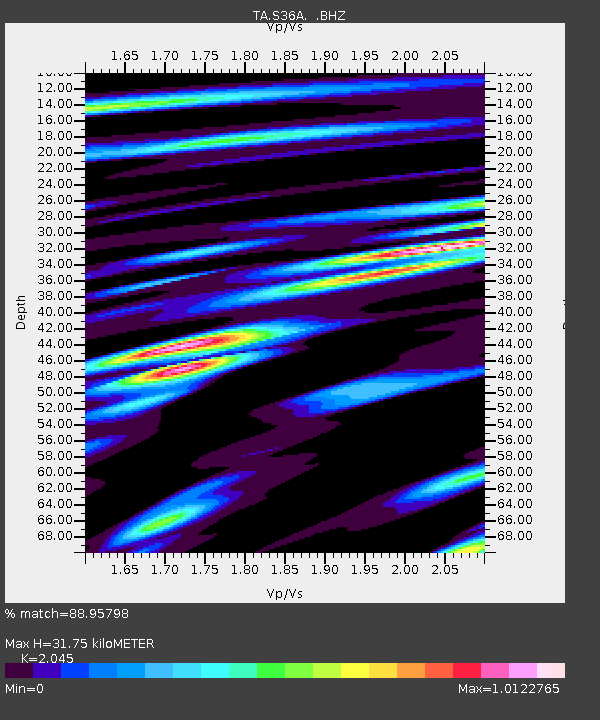
| Estimated Moho Depth: |
31.75 km |
| Estimated Crust Vp/Vs: |
2.05 |
| Assumed Crust Vp: |
6.53 km/s |
| Estimated Crust Vs: |
3.193 km/s |
| Estimated Crust Poisson's Ratio: |
0.34 |
|
| Radial Match: |
88.95798 % |
| Radial Bump: |
400 |
| Transverse Match: |
73.3857 % |
| Transverse Bump: |
400 |
| SOD ConfigId: |
354511 |
| Insert Time: |
2011-08-09 07:58:09.546 +0000 |
| GWidth: |
2.5 |
| Max Bumps: |
400 |
| Tol: |
0.001 |
|

Signal To Noise
| Channel | StoN | STA | LTA |
| TA:S36A: :BHZ:20110306T12:41:27.975007Z | 12.735008 | 1.5291002E-6 | 1.2007062E-7 |
| TA:S36A: :BHN:20110306T12:41:27.975007Z | 6.090606 | 6.16555E-7 | 1.0123047E-7 |
| TA:S36A: :BHE:20110306T12:41:27.975007Z | 3.047378 | 3.6390662E-7 | 1.194163E-7 |
| Arrivals |
| Ps | 5.3 SECOND |
| PpPs | 14 SECOND |
| PsPs/PpSs | 20 SECOND |


