You are here: Home > Network List > TA - USArray Transportable Network (new EarthScope stations) Stations List
> Station R36A Gordon, Harris, KS, USA > Earthquake Result Viewer
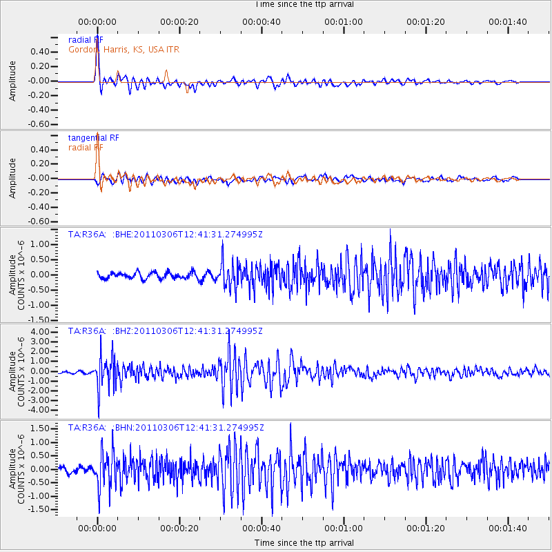
R36A Gordon, Harris, KS, USA - Earthquake Result Viewer
| Earthquake location: |
Northern Chile |
| Earthquake latitude/longitude: |
-18.0/-69.4 |
| Earthquake time(UTC): |
2011/03/06 (065) 12:31:59 GMT |
| Earthquake Depth: |
118 km |
| Earthquake Magnitude: |
6.0 MB, 6.3 MW, 6.3 MW |
| Earthquake Catalog/Contributor: |
WHDF/NEIC |
|
| Network: |
TA USArray Transportable Network (new EarthScope stations) |
| Station: |
R36A Gordon, Harris, KS, USA |
| Lat/Lon: |
38.32 N/95.50 W |
| Elevation: |
354 m |
|
| Distance: |
61.2 deg |
| Az: |
336.702 deg |
| Baz: |
151.413 deg |
| Ray Param: |
0.06070268 |
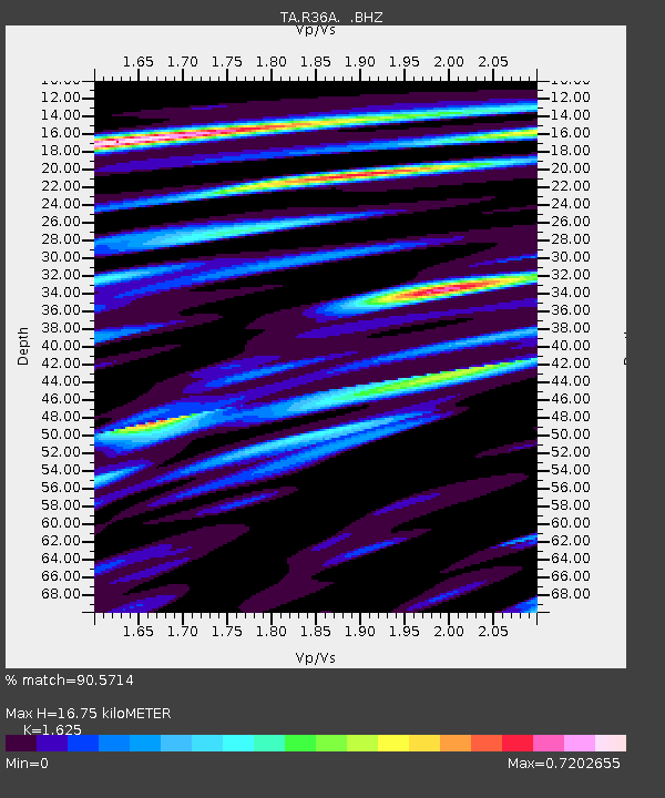
| Estimated Moho Depth: |
16.75 km |
| Estimated Crust Vp/Vs: |
1.62 |
| Assumed Crust Vp: |
6.498 km/s |
| Estimated Crust Vs: |
3.998 km/s |
| Estimated Crust Poisson's Ratio: |
0.20 |
|
| Radial Match: |
90.5714 % |
| Radial Bump: |
365 |
| Transverse Match: |
72.51139 % |
| Transverse Bump: |
400 |
| SOD ConfigId: |
354511 |
| Insert Time: |
2011-08-09 07:59:02.718 +0000 |
| GWidth: |
2.5 |
| Max Bumps: |
400 |
| Tol: |
0.001 |
|
Signal To Noise
| Channel | StoN | STA | LTA |
| TA:R36A: :BHZ:20110306T12:41:31.274995Z | 14.296493 | 1.6349433E-6 | 1.1435975E-7 |
| TA:R36A: :BHN:20110306T12:41:31.274995Z | 5.971637 | 6.88445E-7 | 1.1528581E-7 |
| TA:R36A: :BHE:20110306T12:41:31.274995Z | 4.078718 | 4.2354355E-7 | 1.0384232E-7 |
| Arrivals |
| Ps | 1.7 SECOND |
| PpPs | 6.4 SECOND |
| PsPs/PpSs | 8.1 SECOND |


