You are here: Home > Network List > TA - USArray Transportable Network (new EarthScope stations) Stations List
> Station P35A Duane Minner, Soldier, KS, USA > Earthquake Result Viewer
P35A Duane Minner, Soldier, KS, USA - Earthquake Result Viewer

| Earthquake location: |
Northern Chile |
| Earthquake latitude/longitude: |
-18.0/-69.4 |
| Earthquake time(UTC): |
2011/03/06 (065) 12:31:59 GMT |
| Earthquake Depth: |
118 km |
| Earthquake Magnitude: |
6.0 MB, 6.3 MW, 6.3 MW |
| Earthquake Catalog/Contributor: |
WHDF/NEIC |
|
| Network: |
TA USArray Transportable Network (new EarthScope stations) |
| Station: |
P35A Duane Minner, Soldier, KS, USA |
| Lat/Lon: |
39.53 N/96.02 W |
| Elevation: |
418 m |
|
| Distance: |
62.4 deg |
| Az: |
336.957 deg |
| Baz: |
151.211 deg |
| Ray Param: |
0.059895404 |
| Estimated Moho Depth: |
20.75 km |
| Estimated Crust Vp/Vs: |
1.89 |
| Assumed Crust Vp: |
6.483 km/s |
| Estimated Crust Vs: |
3.434 km/s |
| Estimated Crust Poisson's Ratio: |
0.30 |
|
| Radial Match: |
86.0141 % |
| Radial Bump: |
400 |
| Transverse Match: |
76.48534 % |
| Transverse Bump: |
400 |
| SOD ConfigId: |
354511 |
| Insert Time: |
2011-08-09 08:07:36.751 +0000 |
| GWidth: |
2.5 |
| Max Bumps: |
400 |
| Tol: |
0.001 |
|
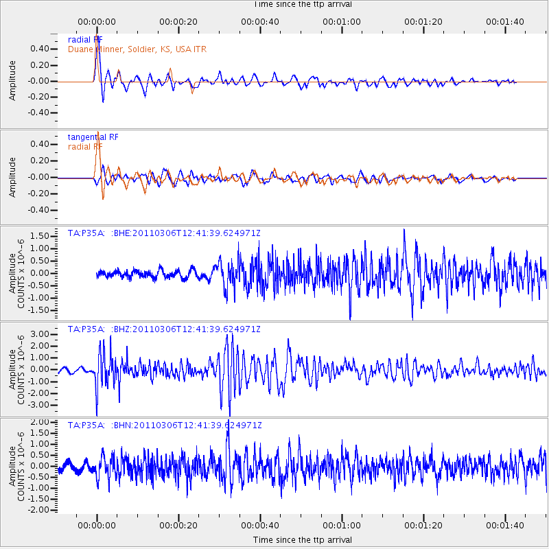
Signal To Noise
| Channel | StoN | STA | LTA |
| TA:P35A: :BHZ:20110306T12:41:39.624971Z | 9.555397 | 1.4216351E-6 | 1.4877824E-7 |
| TA:P35A: :BHN:20110306T12:41:39.624971Z | 2.1928828 | 4.6970732E-7 | 2.1419628E-7 |
| TA:P35A: :BHE:20110306T12:41:39.624971Z | 3.892217 | 5.388223E-7 | 1.3843584E-7 |
| Arrivals |
| Ps | 3.0 SECOND |
| PpPs | 8.9 SECOND |
| PsPs/PpSs | 12 SECOND |


