You are here: Home > Network List > TA - USArray Transportable Network (new EarthScope stations) Stations List
> Station T37A Cheneyville 1850, Columbus, KS, USA > Earthquake Result Viewer
T37A Cheneyville 1850, Columbus, KS, USA - Earthquake Result Viewer
| Earthquake location: |
Northern Chile |
| Earthquake latitude/longitude: |
-18.0/-69.4 |
| Earthquake time(UTC): |
2011/03/06 (065) 12:31:59 GMT |
| Earthquake Depth: |
118 km |
| Earthquake Magnitude: |
6.0 MB, 6.3 MW, 6.3 MW |
| Earthquake Catalog/Contributor: |
WHDF/NEIC |
|
| Network: |
TA USArray Transportable Network (new EarthScope stations) |
| Station: |
T37A Cheneyville 1850, Columbus, KS, USA |
| Lat/Lon: |
37.12 N/94.92 W |
| Elevation: |
256 m |
|
| Distance: |
59.9 deg |
| Az: |
336.515 deg |
| Baz: |
151.678 deg |
| Ray Param: |
0.061530557 |
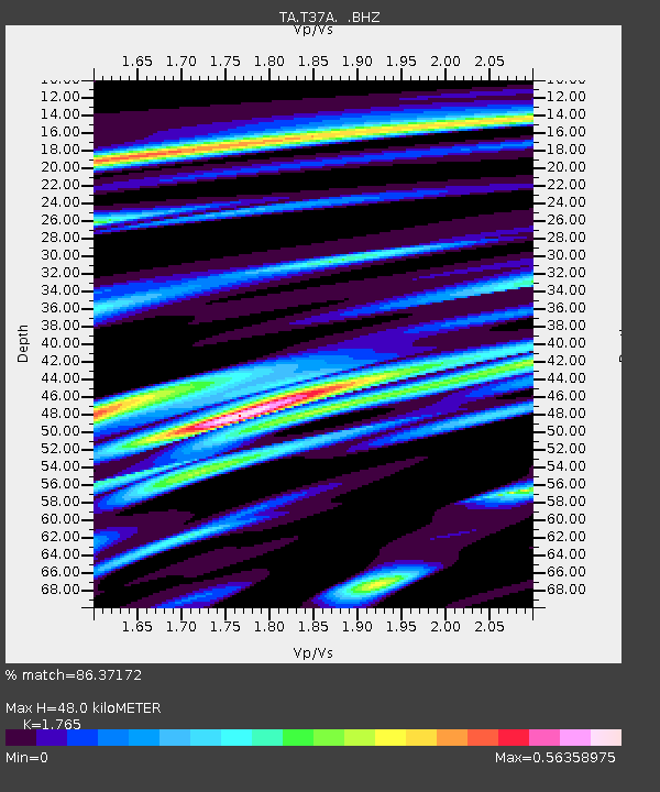
| Estimated Moho Depth: |
48.0 km |
| Estimated Crust Vp/Vs: |
1.76 |
| Assumed Crust Vp: |
6.53 km/s |
| Estimated Crust Vs: |
3.7 km/s |
| Estimated Crust Poisson's Ratio: |
0.26 |
|
| Radial Match: |
86.37172 % |
| Radial Bump: |
288 |
| Transverse Match: |
59.421204 % |
| Transverse Bump: |
393 |
| SOD ConfigId: |
354511 |
| Insert Time: |
2011-08-09 08:09:21.644 +0000 |
| GWidth: |
2.5 |
| Max Bumps: |
400 |
| Tol: |
0.001 |
|

Signal To Noise
| Channel | StoN | STA | LTA |
| TA:T37A: :BHZ:20110306T12:41:22.624971Z | 12.529217 | 1.3476218E-6 | 1.0755835E-7 |
| TA:T37A: :BHN:20110306T12:41:22.624971Z | 6.5840974 | 6.8323726E-7 | 1.0377084E-7 |
| TA:T37A: :BHE:20110306T12:41:22.624971Z | 4.5039806 | 3.9799554E-7 | 8.836529E-8 |
| Arrivals |
| Ps | 5.9 SECOND |
| PpPs | 19 SECOND |
| PsPs/PpSs | 25 SECOND |


