You are here: Home > Network List > TA - USArray Transportable Network (new EarthScope stations) Stations List
> Station K35A Storm Lake, IA, USA > Earthquake Result Viewer
K35A Storm Lake, IA, USA - Earthquake Result Viewer
| Earthquake location: |
Northern Chile |
| Earthquake latitude/longitude: |
-18.0/-69.4 |
| Earthquake time(UTC): |
2011/03/06 (065) 12:31:59 GMT |
| Earthquake Depth: |
118 km |
| Earthquake Magnitude: |
6.0 MB, 6.3 MW, 6.3 MW |
| Earthquake Catalog/Contributor: |
WHDF/NEIC |
|
| Network: |
TA USArray Transportable Network (new EarthScope stations) |
| Station: |
K35A Storm Lake, IA, USA |
| Lat/Lon: |
42.72 N/95.23 W |
| Elevation: |
439 m |
|
| Distance: |
65.0 deg |
| Az: |
339.214 deg |
| Baz: |
152.727 deg |
| Ray Param: |
0.058253728 |
| Estimated Moho Depth: |
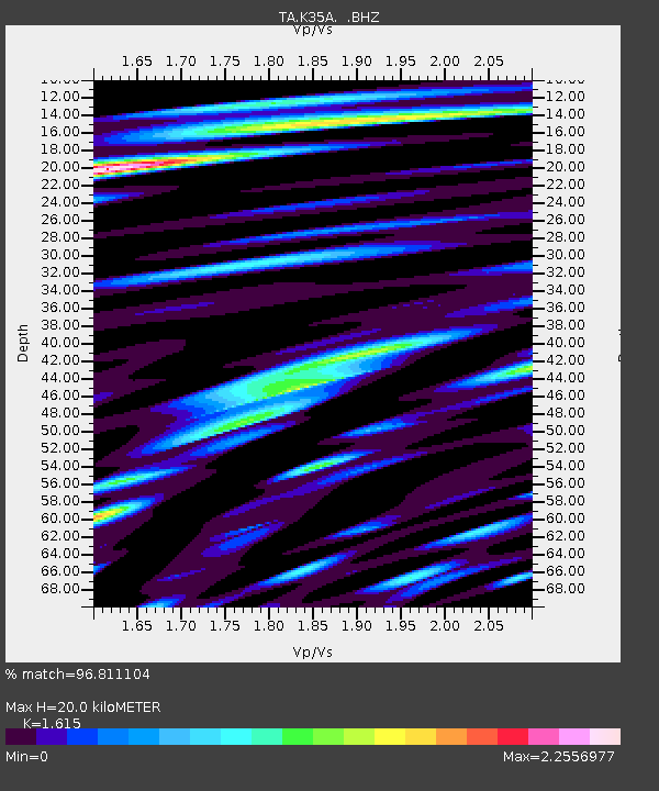
20.0 km |
| Estimated Crust Vp/Vs: |
1.62 |
| Assumed Crust Vp: |
6.53 km/s |
| Estimated Crust Vs: |
4.044 km/s |
| Estimated Crust Poisson's Ratio: |
0.19 |
|
| Radial Match: |
96.811104 % |
| Radial Bump: |
400 |
| Transverse Match: |
82.783875 % |
| Transverse Bump: |
400 |
| SOD ConfigId: |
354511 |
| Insert Time: |
2011-08-09 08:20:31.772 +0000 |
| GWidth: |
2.5 |
| Max Bumps: |
400 |
| Tol: |
0.001 |
|
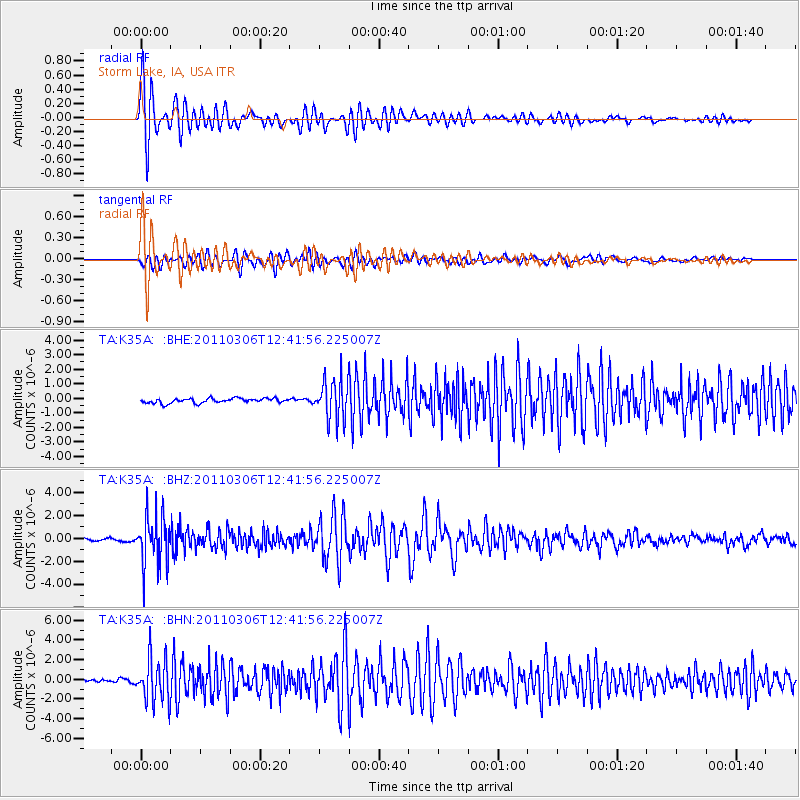
Signal To Noise
| Channel | StoN | STA | LTA |
| TA:K35A: :BHZ:20110306T12:41:56.225007Z | 16.119858 | 2.18856E-6 | 1.3576795E-7 |
| TA:K35A: :BHN:20110306T12:41:56.225007Z | 19.769993 | 2.2197517E-6 | 1.1227883E-7 |
| TA:K35A: :BHE:20110306T12:41:56.225007Z | 8.518969 | 1.3668451E-6 | 1.6044726E-7 |
| Arrivals |
| Ps | 2.0 SECOND |
| PpPs | 7.6 SECOND |
| PsPs/PpSs | 9.6 SECOND |


