You are here: Home > Network List > UW - Pacific Northwest Regional Seismic Network Stations List
> Station PASS Maple Falls, WA, USA > Earthquake Result Viewer
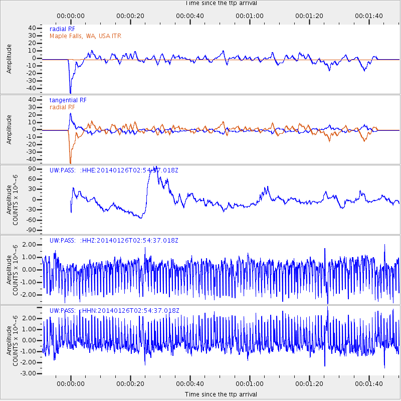
PASS Maple Falls, WA, USA - Earthquake Result Viewer
*The percent match for this event was below the threshold and hence no stack was calculated.
| Earthquake location: |
Leyte, Philippines |
| Earthquake latitude/longitude: |
11.2/124.6 |
| Earthquake time(UTC): |
2014/01/26 (026) 02:41:40 GMT |
| Earthquake Depth: |
13 km |
| Earthquake Magnitude: |
5.0 MW |
| Earthquake Catalog/Contributor: |
ISC/ISC |
|
| Network: |
UW Pacific Northwest Regional Seismic Network |
| Station: |
PASS Maple Falls, WA, USA |
| Lat/Lon: |
49.00 N/122.09 W |
| Elevation: |
174 m |
|
| Distance: |
96.3 deg |
| Az: |
37.497 deg |
| Baz: |
294.922 deg |
| Ray Param: |
$rayparam |
*The percent match for this event was below the threshold and hence was not used in the summary stack. |
|
| Radial Match: |
65.930664 % |
| Radial Bump: |
400 |
| Transverse Match: |
66.96409 % |
| Transverse Bump: |
400 |
| SOD ConfigId: |
3390531 |
| Insert Time: |
2019-04-10 02:47:02.062 +0000 |
| GWidth: |
2.5 |
| Max Bumps: |
400 |
| Tol: |
0.001 |
|
Signal To Noise
| Channel | StoN | STA | LTA |
| UW:PASS: :HHZ:20140126T02:54:37.018Z | 0.96995896 | 7.8709616E-7 | 8.114737E-7 |
| UW:PASS: :HHN:20140126T02:54:37.018Z | 0.9485791 | 8.7528815E-7 | 9.227361E-7 |
| UW:PASS: :HHE:20140126T02:54:37.018Z | 2.913311 | 6.297089E-5 | 2.1614887E-5 |
| Arrivals |
| Ps | |
| PpPs | |
| PsPs/PpSs | |


