You are here: Home > Network List > AZ - ANZA Regional Network Stations List
> Station KNW AZ.KNW > Earthquake Result Viewer
KNW AZ.KNW - Earthquake Result Viewer
| Earthquake location: |
Fiji Islands Region |
| Earthquake latitude/longitude: |
-21.7/-179.5 |
| Earthquake time(UTC): |
1999/03/06 (065) 20:28:53 GMT |
| Earthquake Depth: |
603 km |
| Earthquake Magnitude: |
5.4 MB, 5.8 MW, 5.7 MW |
| Earthquake Catalog/Contributor: |
WHDF/NEIC |
|
| Network: |
AZ ANZA Regional Network |
| Station: |
KNW AZ.KNW |
| Lat/Lon: |
33.71 N/116.71 W |
| Elevation: |
1507 m |
|
| Distance: |
81.3 deg |
| Az: |
48.563 deg |
| Baz: |
236.745 deg |
| Ray Param: |
0.04584196 |
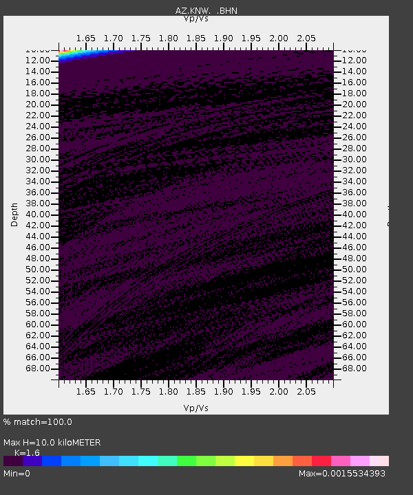
| Estimated Moho Depth: |
10.0 km |
| Estimated Crust Vp/Vs: |
1.60 |
| Assumed Crust Vp: |
6.264 km/s |
| Estimated Crust Vs: |
3.915 km/s |
| Estimated Crust Poisson's Ratio: |
0.18 |
|
| Radial Match: |
100.0 % |
| Radial Bump: |
2 |
| Transverse Match: |
100.0 % |
| Transverse Bump: |
2 |
| SOD ConfigId: |
32974 |
| Insert Time: |
2010-02-26 19:33:45.133 +0000 |
| GWidth: |
2.5 |
| Max Bumps: |
400 |
| Tol: |
0.001 |
|
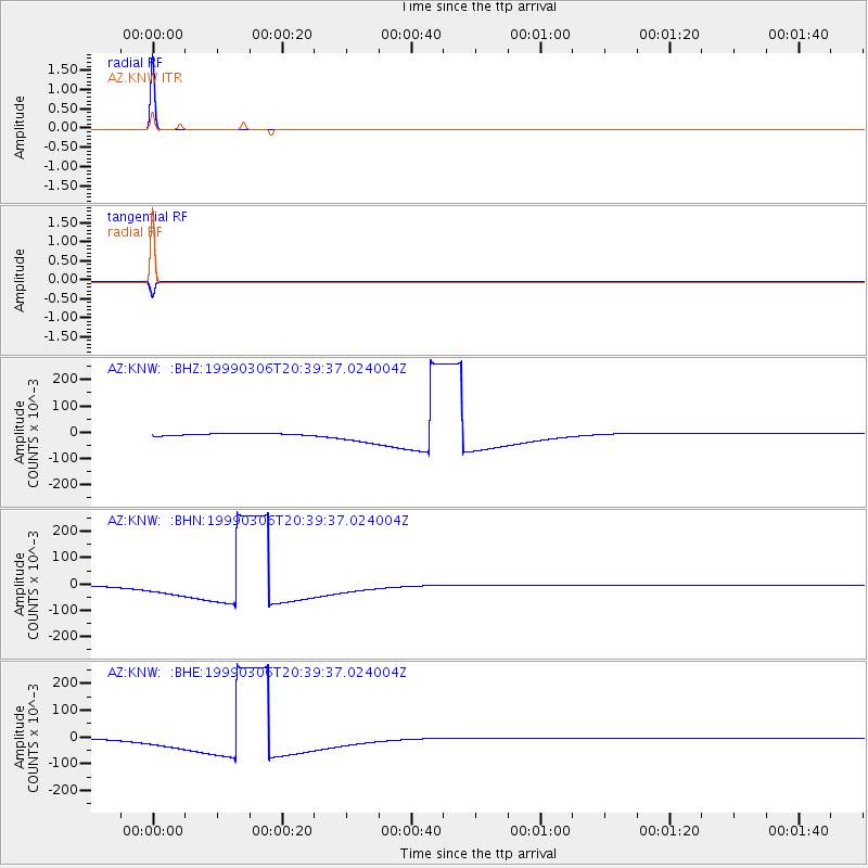
Signal To Noise
| Channel | StoN | STA | LTA |
| AZ:KNW: :BHN:19990306T20:39:37.024004Z | 7.784669 | 0.02784971 | 0.0035775073 |
| AZ:KNW: :BHE:19990306T20:39:37.024004Z | 7.7841315 | 0.027848631 | 0.0035776156 |
| AZ:KNW: :BHZ:19990306T20:39:37.024004Z | 7.7839274 | 0.027848683 | 0.0035777162 |
| Arrivals |
| Ps | 1.0 SECOND |
| PpPs | 4.0 SECOND |
| PsPs/PpSs | 5.0 SECOND |


